Early Los Angeles City Views (1800s)
From Pueblo to Growing City
Historical Photos of Early Los Angeles |
Introduction |
This page captures Los Angeles during the Boom of the Eighties, the decade when a relatively small regional city began rapidly expanding into a major urban center. It opens with the Second Street Cable Railway, whose route across Bunker Hill helped open the developing Crown Hill district to easier access, and follows that same period of growth through the streets, hotels, civic buildings, railways, and new communities taking shape across the region.Two forces played especially important roles in that transformation. The arrival of the Santa Fe Railroad in 1885 challenged the Southern Pacific’s dominance and helped fuel the great real estate boom of the decade. At the same time, new transportation technology was changing how Angelenos moved through the city. Cable railways could negotiate grades that challenged horse-drawn streetcars, while Los Angeles’ first electric streetcars began operating on Pico Street in January 1887.The photographs that follow show how widely that growth was spreading. Alongside downtown landmarks such as City Hall, the Los Angeles Times Building, and the Bryson-Bonebrake Block, the page reaches outward to Crown Hill, Boyle Heights, Highland Park, Hollywood, and Compton, which incorporated in 1888. Horse-drawn vehicles still crowded unpaved streets, even as cable railways, steam trains, electric streetcars, and electric power signaled the city that was coming next. Together, these images capture Los Angeles at a turning point between its 19th-century past and the metropolitan city it was rapidly becoming. |
* * * * * |
The Second Street Cable Railway |
Los Angeles' First Cable Car Line, 1885–1889 |
In 1885, Los Angeles entered a new era of urban transportation with the opening of the Second Street Cable Railway. The line was built to carry passengers from downtown across Bunker Hill to the developing Crown Hill district west of the city center. In doing so, it became Los Angeles' first cable railway and helped demonstrate how improved transportation could open previously difficult-to-reach land to development.Building the railway required extending Second Street westward through the hills and cutting into the terrain of Bunker Hill. Even after this grading, the line faced an exceptionally steep climb. Between Hope Street and Bunker Hill Avenue, the grade reached 27.7 percent, identified as the steepest cable railway gradient in North America at the time. A powerhouse and car house at Second and Boylston streets operated the continuously moving underground cable that pulled the cars along the route. Testing began on October 8, 1885, and regular service started six days later on October 14.The railway's life was brief. The company struggled financially, while rainwater repeatedly entered the poorly drained underground cable conduit, damaging cables and pulleys and disrupting service. A severe storm on December 24, 1889, finally damaged the system beyond repair. After only about four years, Los Angeles' first cable railway was finished. Other cable railways continued operating in the city, but electric streetcars soon offered a simpler and more economical alternative. |
Crown Hill
 |
|
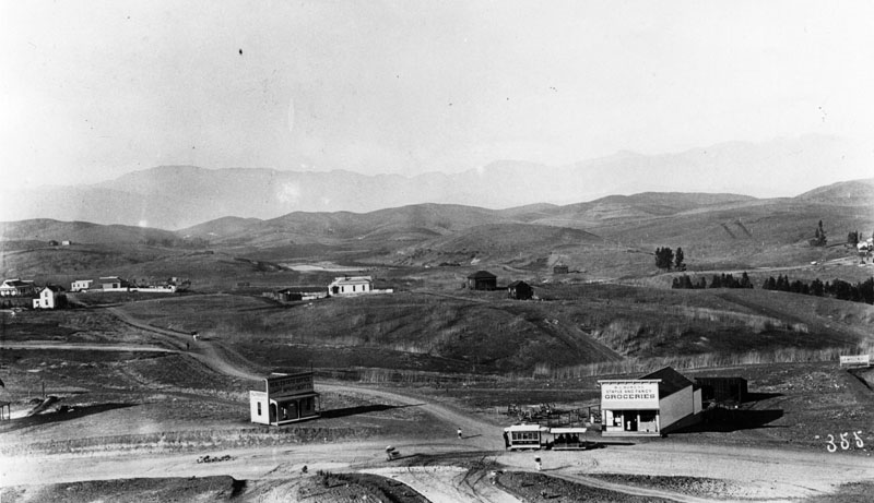
| (ca. 1885–1886)^ – Panoramic view of Crown Hill west of downtown Los Angeles. In the foreground, a car of the Second Street Cable Railway is stopped near W. C. Bowers' staple and fancy groceries store. A small real estate office stands at left, while scattered dwellings occupy the still largely undeveloped hills beyond. |
Historical Notes During the 1880s, the hills west of downtown were being promoted for residential development. Crown Hill emerged as one of these new districts, and convenient transportation was essential if developers hoped to attract residents to an area separated from downtown by the steep terrain of Bunker Hill. The Second Street Cable Railway helped make that development possible. Prospective buyers and residents could travel from downtown across Bunker Hill and into Crown Hill without relying on horse-drawn streetcars to negotiate the difficult grades. Stores, hotels, residences, and other development soon began appearing along and near the route. This photograph captures Crown Hill at an early stage of that transformation. The grocery store and real estate office in the foreground stand against a background of mostly open hills, illustrating the close relationship between transportation and real estate development in late-19th-century Los Angeles. |
Second Street Cable Railway
 |
|
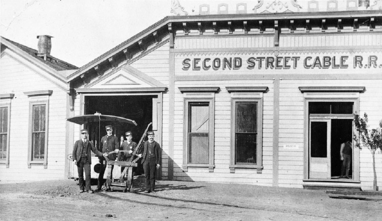
| (ca. 1885) – Exterior view of the car house and powerhouse of the Second Street Cable Railway at Second and Boylston streets, with uniformed railway employees posing in front. |
Historical Notes The Second Street Cable Railway was Los Angeles' first cable railway. Regular service began on October 14, 1885, operating over a single-track route between downtown and the developing area west of Bunker Hill. Passing sidings allowed cars traveling in opposite directions to meet along the route. The railway initially operated about 80 trips per day. The power station and car house at Second and Boylston streets stood near the middle of the line. A stationary steam engine kept a heavy steel cable moving continuously through a conduit beneath the street. Each cable car used a mechanical grip extending through a slot in the roadway to grasp the moving cable and pull the car along. This system made steep grades practical, but it also required an extensive network of cables, pulleys, conduits, and machinery beneath the street. That mechanical complexity would eventually become one of the major disadvantages of cable transportation. |
 |
|
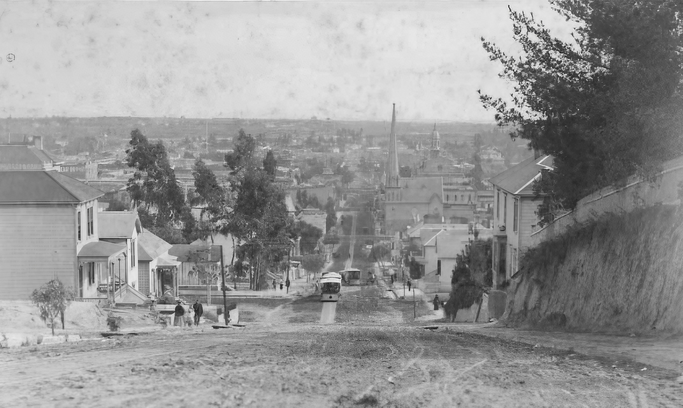
| (ca. 1885)* – View looking east on Second Street from Olive Street, showing two cars of the Second Street Cable Railway at center. The tall spire of the First Presbyterian Church can be seen in the distance at the southeast corner of Second and Fort streets, later Broadway. Farther east is the cupola of St. Vibiana's Cathedral near Second and Main streets. |
Historical Notes The Second Street Cable Railway initially operated about 80 trips per day. From downtown, cars traveled west along Second Street, crossed Bunker Hill, and continued toward Crown Hill. The line's most difficult section was between Hope Street and Bunker Hill Avenue, where the grade reached 27.7 percent. Cable traction made such a climb possible because the cars were pulled by a continuously moving cable beneath the street rather than by horses. The two cars visible here also illustrate how traffic could operate in both directions despite the railway being primarily a single-track system. Passing sidings at intervals allowed opposing cars to meet and continue along the route. |
 |
|
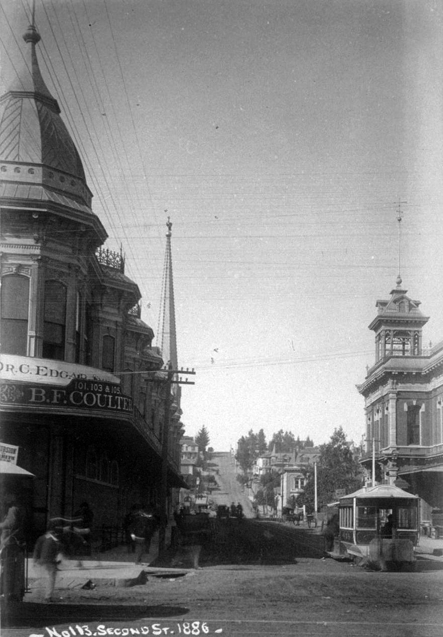
| (1886)* - View looking west on Second Street from Spring Street as a car of the Second Street Cable Railway heads toward Bunker Hill. Los Angeles' second City Hall, which served from 1884 to 1888, stands at right. At left are the two-story Hollenbeck Block and the spire of the First Presbyterian Church. |
Historical Notes This view shows the downtown end of the Second Street Cable Railway shortly after the line opened. From Second and Spring streets, cars headed west toward Bunker Hill before continuing through the cuts in the hillside toward Crown Hill. Within only a few blocks, the relatively level downtown street gave way to the most demanding part of the route. The cable car would soon approach the 27.7 percent grade between Hope Street and Bunker Hill Avenue, a climb identified as the steepest cable railway gradient in North America. The photograph also captures downtown Los Angeles during a period of rapid growth. City Hall, the Hollenbeck Block, churches, and the new cable railway all occupied a compact area that would change substantially before the end of the century. |
Then and Now
 |
|
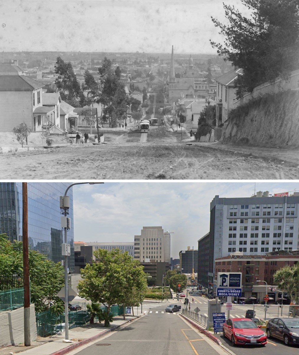
| (1885 vs. 2021)* - Looking east on Second Street from near Olive Street in downtown Los Angeles. The upper view shows two cars of the Second Street Cable Railway on the original surface route over Bunker Hill. In the lower view, Second Street follows a different grade toward the Second Street Tunnel, located at right below the parking structure. Photo comparison by Jack Feldman. |
Historical Notes The two views show different solutions to the same geographic obstacle. In the 1880s, cable technology allowed streetcars to climb over Bunker Hill. By the early 20th century, growing automobile traffic led Los Angeles to pursue another approach: passing through the hill rather than over it. Work toward construction of the Second Street Tunnel began in 1916 but was delayed for several years by litigation. Major excavation began in 1921, and the tunnel opened in 1924. Construction of the tunnel altered the grade and alignment of Second Street, which is why the historic and modern streets do not line up exactly in this comparison. Later redevelopment of Bunker Hill transformed the surrounding landscape even further. |
Cutting Through Bunker Hill
 |
|
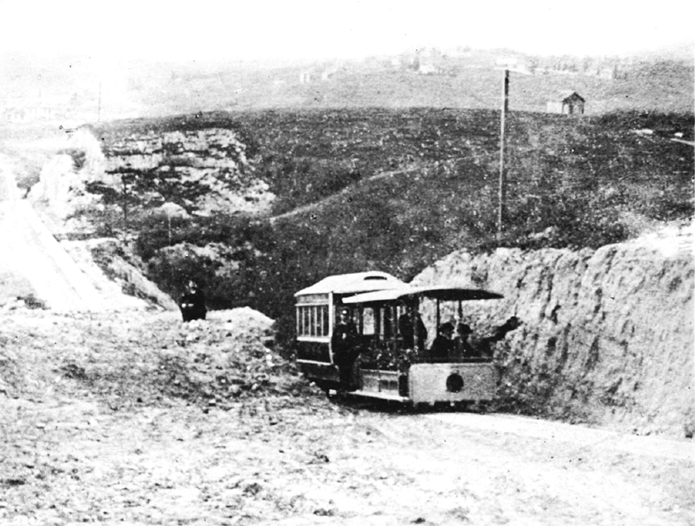
| (ca. 1885)* - A car of the Second Street Cable Railway passes through a deep cut along Second Street on Bunker Hill. Beyond the cut is the lightly developed area west of downtown that the railway helped make more accessible. |
Historical Notes Building the Second Street Cable Railway required more than laying tracks. Second Street had to be extended westward through difficult terrain, and portions of Bunker Hill were cut away to create a workable route. Even after the grading, the railway still faced a 27.7 percent grade between Hope Street and Bunker Hill Avenue. That steep section became one of the line's defining engineering features and demonstrated why cable traction was particularly useful in hilly terrain. The project also helped change the geography of western Los Angeles. By improving access across Bunker Hill, the railway provided a transportation link between downtown and the developing Crown Hill district. The open hills visible beyond the cut would soon begin filling with houses, businesses, and other development. |
 |
|
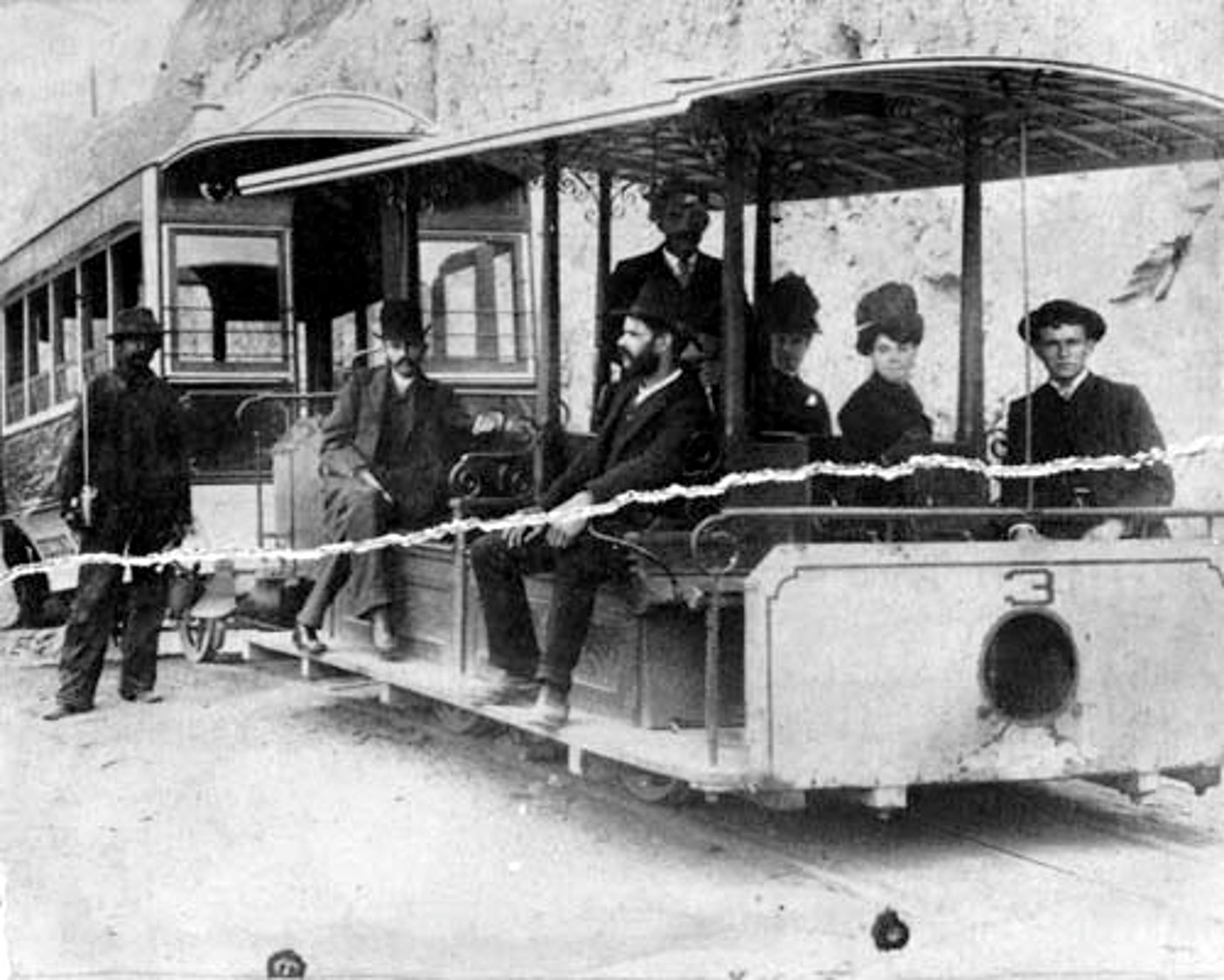
| (ca. 1886)* – Close-up view showing passengers posing aboard a car of the Second Street Cable Railway. |
Historical Notes Unlike an electric streetcar, a cable car carried no propulsion motor. Power came from a stationary engine at the powerhouse, which kept a steel cable moving continuously beneath the street. A gripman aboard the car operated a mechanical grip extending through a slot between the rails, attaching the car to the moving cable when power was needed. The system worked particularly well on steep grades, but it required extensive machinery beneath the roadway. Cables, pulleys, conduits, and other components had to be maintained continuously, and damage anywhere along the system could interfere with service. These disadvantages became increasingly important as electric streetcars improved. Rather than relying on a continuously moving underground cable, electric cars carried their own motors and received power through overhead wires. During the 1890s, electricity increasingly replaced cable traction throughout Los Angeles. Click HERE to see more in Cable Railways Into Obsolescence – The End of the Second Street Line. |
 |
|
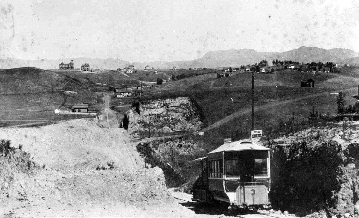
| (ca. 1886)* – View looking west as a two-car train of the Second Street Cable Railway passes through the Bunker Hill cut toward Crown Hill. The Belmont Hotel can be seen in the distance at upper left. |
Historical Notes The Second Street Cable Railway could operate a grip car with a trailing passenger car, increasing capacity while using the same moving cable for propulsion. The deep cut seen here helped reduce the severity of the terrain, although the route still included unusually steep grades. In the distance, the Belmont Hotel stands atop Crown Hill near the western end of the line. The building originally housed Ellis Villa College, a school for young women that opened in 1884. After a new college building was constructed nearby, the original building was converted into the Belmont Hotel, which opened in 1886. Both buildings had remarkably short lives. The Belmont Hotel was destroyed by fire in December 1887, and the newer Ellis College building burned in July 1888. Belmont High School later opened on the property, preserving a name associated with this early chapter of Crown Hill's history. |
 |
|
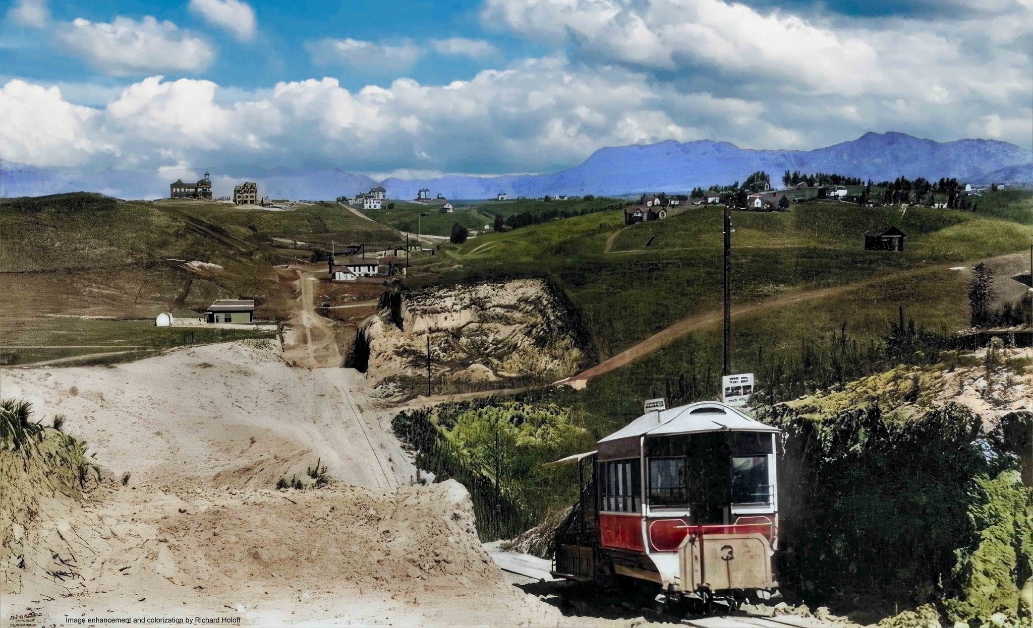
| (ca. 1886)* – View looking west as a two-car train of the Second Street Cable Railway passes through the Bunker Hill cut toward Crown Hill. The Belmont Hotel is visible at upper left. Image enhancement and colorization by Richard Holoff. |
Historical Notes This colorized view provides a clearer sense of the largely open landscape surrounding Crown Hill during the mid-1880s. The Belmont Hotel can be seen at upper left, while nearby development remained scattered across the hills. Nearby stood the newer Ellis College building and Second Street Park, both part of the growth taking place west of downtown after improved transportation made the area easier to reach. The Belmont Hotel was destroyed by fire in 1887, followed by the loss of Ellis College to fire in 1888. The photograph captures a brief moment when Crown Hill appeared poised for substantial growth. The cable railway, hotel, college, park, stores, and new residences were all part of an effort to transform previously sparsely settled hills into an extension of the growing city. |
 |
|
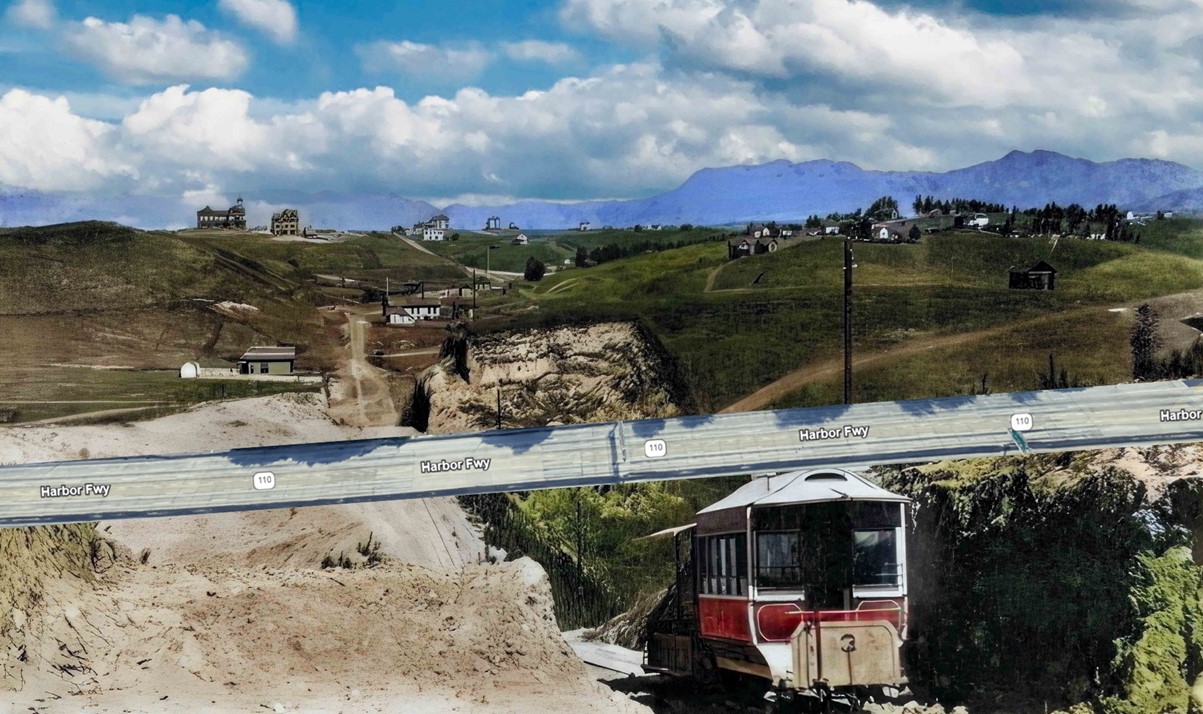
| (1886 / 2024)* – A two-car train of the Second Street Cable Railway heads west through the Bunker Hill cut toward Crown Hill, with the Belmont Hotel visible at upper left. Today's Harbor Freeway is superimposed on the historic scene to show how extensively the area has changed. The former Belmont Hotel site is now occupied by Belmont High School. Photo comparison by Jack Feldman. |
Historical Notes This comparison shows how thoroughly the landscape west of downtown has been transformed since the cable railway era. Hillsides were graded, streets altered, buildings demolished, and new transportation routes constructed as Los Angeles expanded during the 20th century. The Second Street Cable Railway itself lasted only about four years. The company struggled financially, and rainwater repeatedly entered its poorly drained underground conduit, damaging cables and pulleys. Service was interrupted for weeks in early 1888 when mud prevented a replacement cable from reaching the powerhouse. Then, on December 24, 1889, a severe storm damaged the system beyond repair. The Second Street Cable Railway became the first operational cable-car line in the United States to be abandoned. Its short life nevertheless marked an important transition in Los Angeles transportation. Cable cars demonstrated that mechanical transit could overcome terrain that had limited horse-drawn streetcars, while the development of Crown Hill showed how closely transportation and real estate growth were becoming linked. Electric streetcars would soon extend that relationship across a much larger part of Los Angeles. Click HERE to see more in Cable Railways Into Obsolescence – The End of the Second Street Line. |
* * * * * |
Crown Hill — Los Angeles’ New West End |
In the mid-1880s, Crown Hill was promoted as Los Angeles’ “New West End,” a residential district rising on the hills west of downtown. Developers emphasized its elevated setting, cooling breezes, broad views, and convenient access to the growing business center.Transportation helped make that vision possible. The Second Street Cable Railway opened in 1885, carrying passengers west from Spring Street, across Bunker Hill, and toward Crown Hill. The Belmont Hotel, which opened the following year, became the district’s most visible landmark. Although the hotel survived for only a short time, these views capture Crown Hill during a brief period when homes, orchards, transportation, and real estate development were beginning to reshape the western edge of Los Angeles. |
 |
|
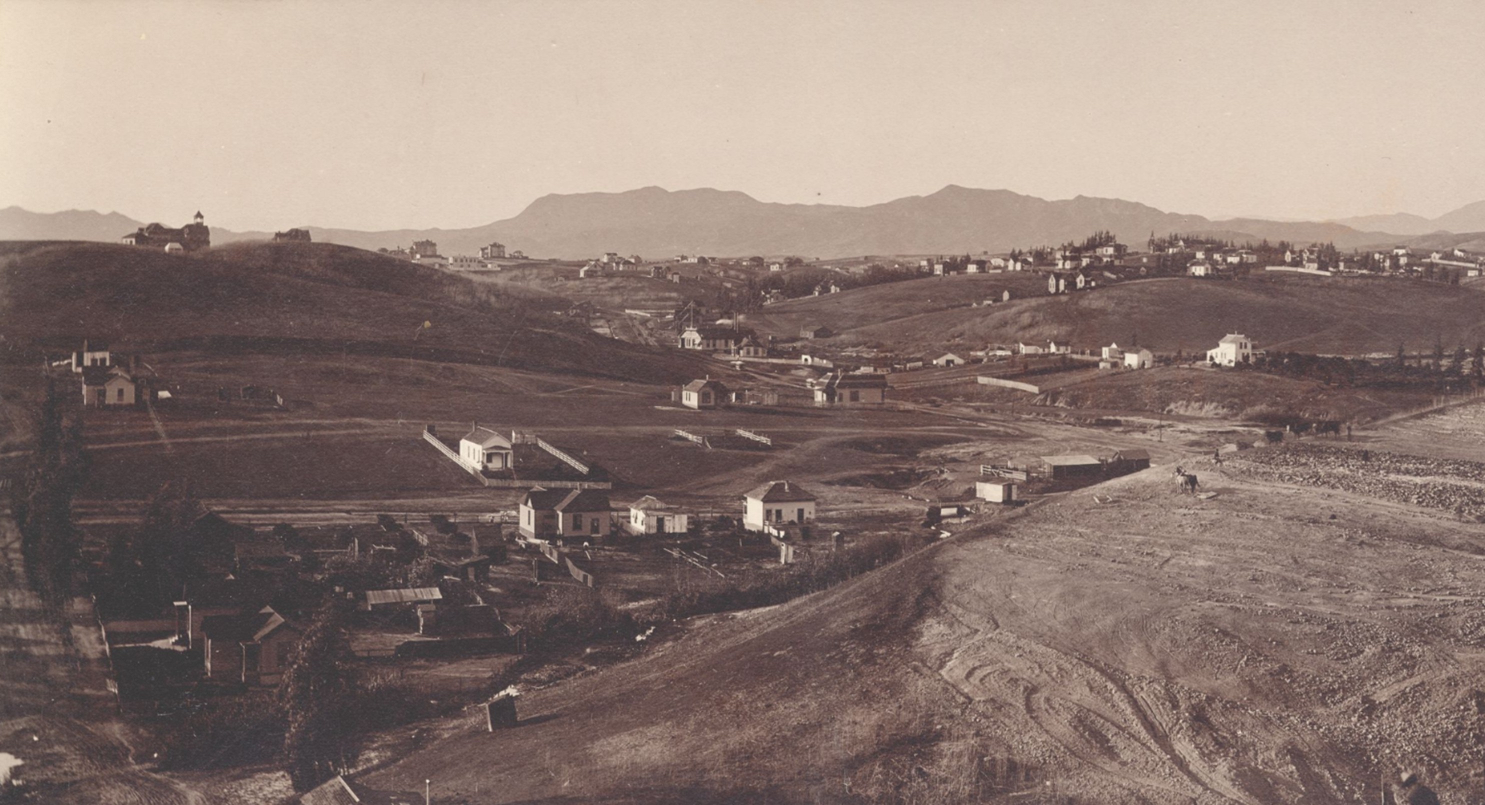
| (ca. 1886)* - Panoramic view looking northwest along Third Street from Grand Avenue. The Belmont Hotel can be seen in the distance atop Crown Hill. Photo by C. C. Pierce. |
Historical Notes In the mid-1880s, the Los Angeles Improvement Company began developing Crown Hill as an upscale residential district west of downtown. Contemporary accounts called the area the city’s “New West End” and promoted its fresh air, views, and convenient location. The Belmont Hotel, visible on the distant ridge, opened in 1886 in the building that had originally housed Ellis Villa College. Its hilltop location made it a prominent landmark, while the line of Third Street in the foreground shows development beginning to extend west beyond Bunker Hill. |
 |
|
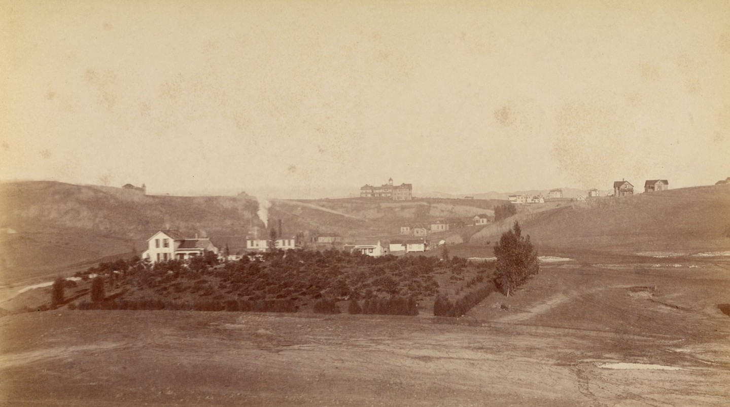
| (ca. 1887)* - View toward Crown Hill, with the Belmont Hotel visible on the distant ridge. Houses, orchards, and open land occupy the slopes below. Photo by W. H. Fletcher. |
Historical Notes This view shows Crown Hill while it was still a mixture of suburban development and open countryside. Scattered houses stood among orchards and gardens, offering residents a setting that felt removed from downtown even though the city center was only a short distance away. The Second Street Cable Railway, opened in 1885, helped connect the developing district with downtown and supported real estate activity west of Bunker Hill. The Belmont Hotel became Crown Hill’s best-known landmark, but its life was brief. On December 16, 1887, a fire destroyed the building, little more than a year after it opened. |
Then and Now
 |
|
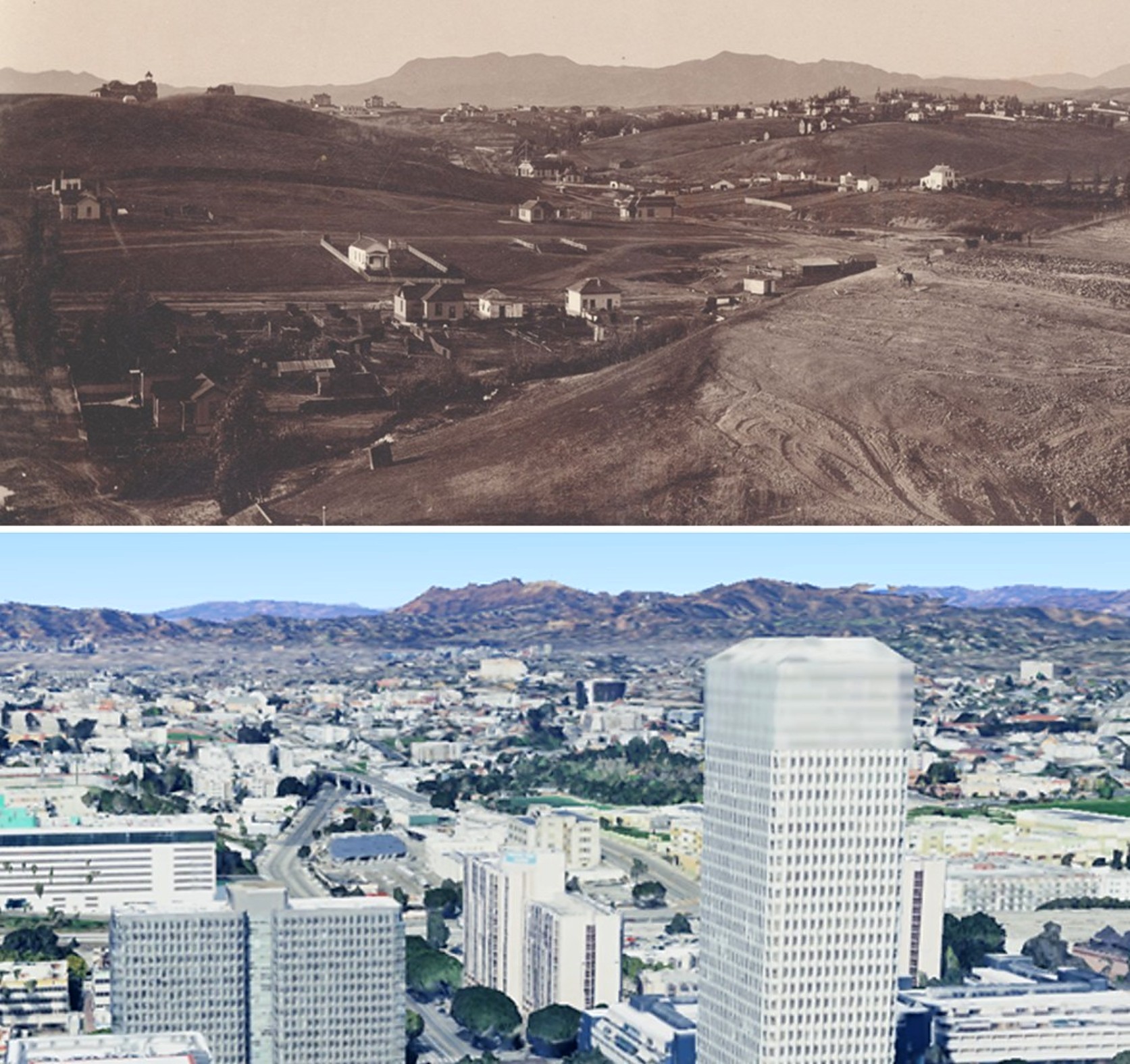
| (1886 vs. 2023)* - Looking northwest from near Third Street and Grand Avenue, the 1886 view shows scattered homes and open hillsides, with the Belmont Hotel visible on Crown Hill in the distance. By 2023, the same view is filled with office towers, freeways, and neighborhoods extending toward the Hollywood Hills. Photo comparison by Jack Feldman. |
Historical Notes The comparison shows the scale of Los Angeles’ growth since the 1880s. Crown Hill and the Belmont Hotel once marked the city’s expanding western edge, while much of the land between Bunker Hill and the distant ridges remained open or only lightly developed. By 2023, streets, freeways, towers, and closely built neighborhoods had absorbed nearly every part of the earlier landscape. The Belmont Hotel disappeared after the fire of 1887, and later development reshaped the hill. Belmont High School opened on Crown Hill in 1923, preserving a name associated with the hotel and this early period of neighborhood growth. |
* * * * * |
Belmont Hotel
 |
|
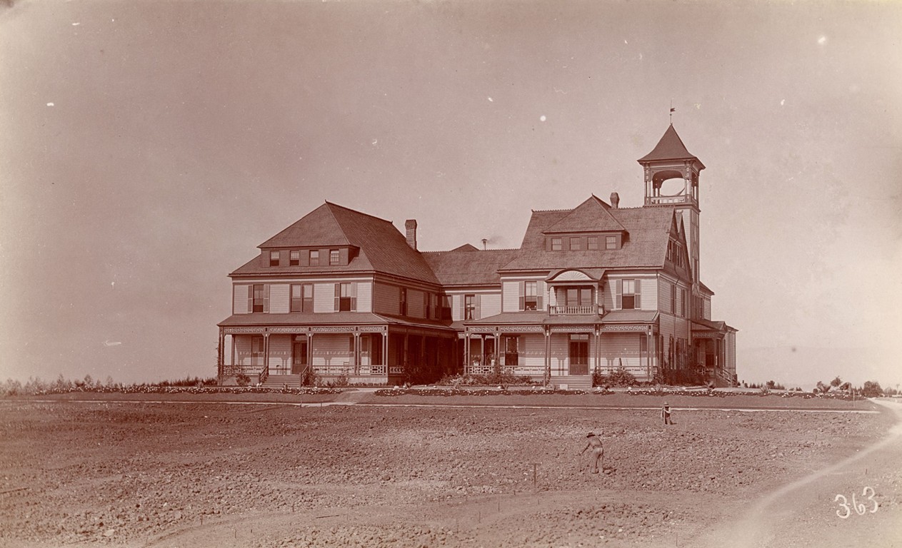
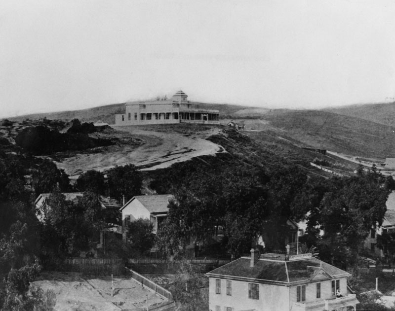
| (1886)* - View showiing the newly construct Belmont Hotel on Crown Hill near the southeast corner of Belmont Avenue and 2nd Street. Photo by W. H. Fletcher. |
Historical Notes The Belmont Hotel opened in July 1886, just one year after the Second Street Cable Railway made Crown Hill easily accessible. Converted from Ellis Villa College, the city’s first finishing school for young women, the three-story shingled hotel offered outward-facing rooms for breezes and views, verandas, and landscaped gardens. It quickly became a favored destination for tourists and social gatherings among Los Angeles’ elite. |
 |
|
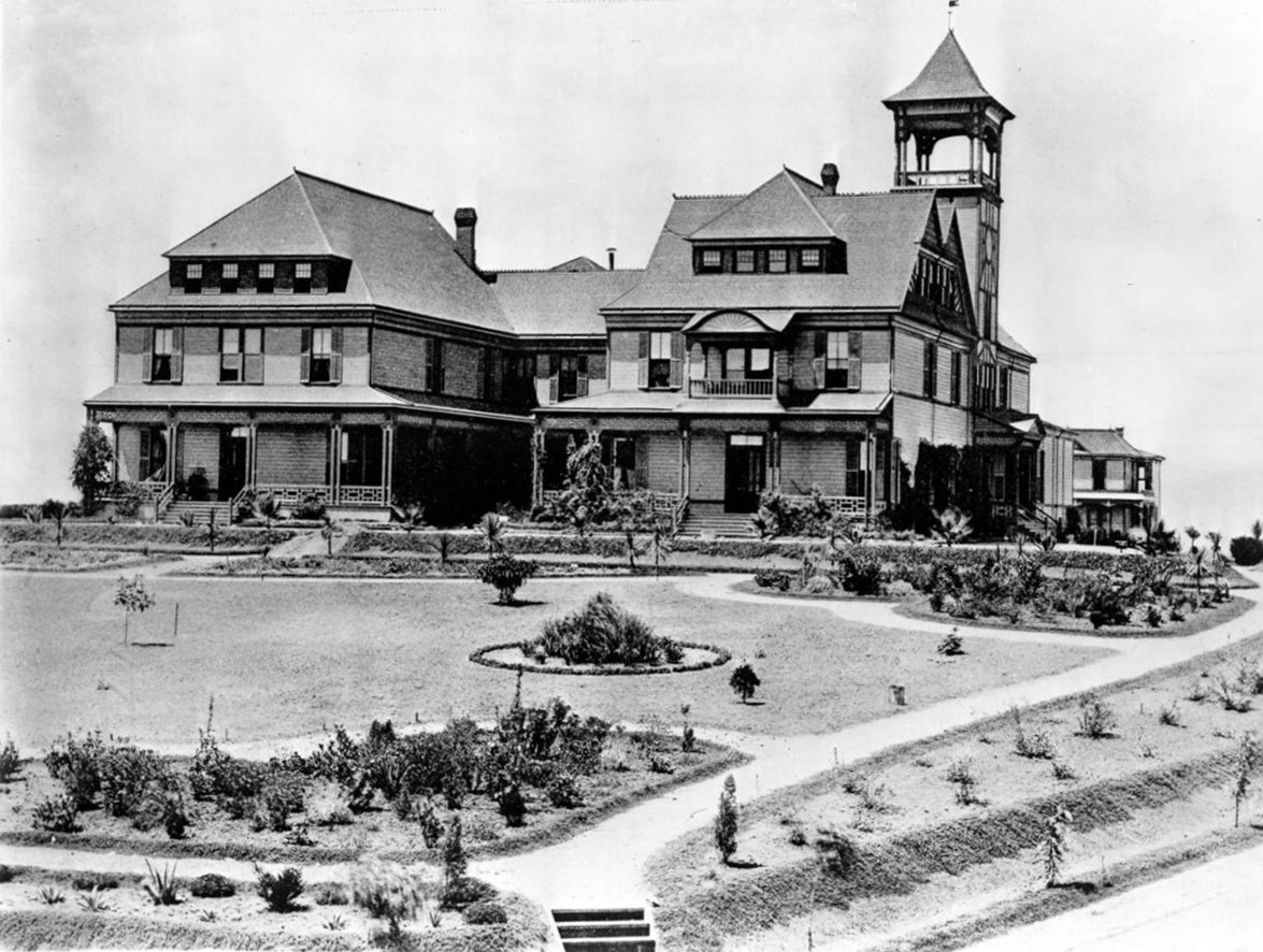
| (1886)* - View of the Belmont Hotel and its yard, Belmont Avenue & 2nd Street. The three-story hotel featured shingled walls, triangular shaped dormer windows, triangular gables, inclined roof, a balcony, and a square tower. |
Historical Notes The Belmont’s architecture reflected the Victorian taste of the boom era—picturesque, asymmetrical, and commanding its ridge-top site. Guests could stroll through croquet lawns, sit in men’s and women’s parlors, or simply enjoy the panoramic views. Rev. John W. Ellis, who had earlier founded Ellis Villa College, retained ownership while leasing hotel operations to R.H. Bryant and his managers, M.E. Clark and Walter Patrick. |
 |
|
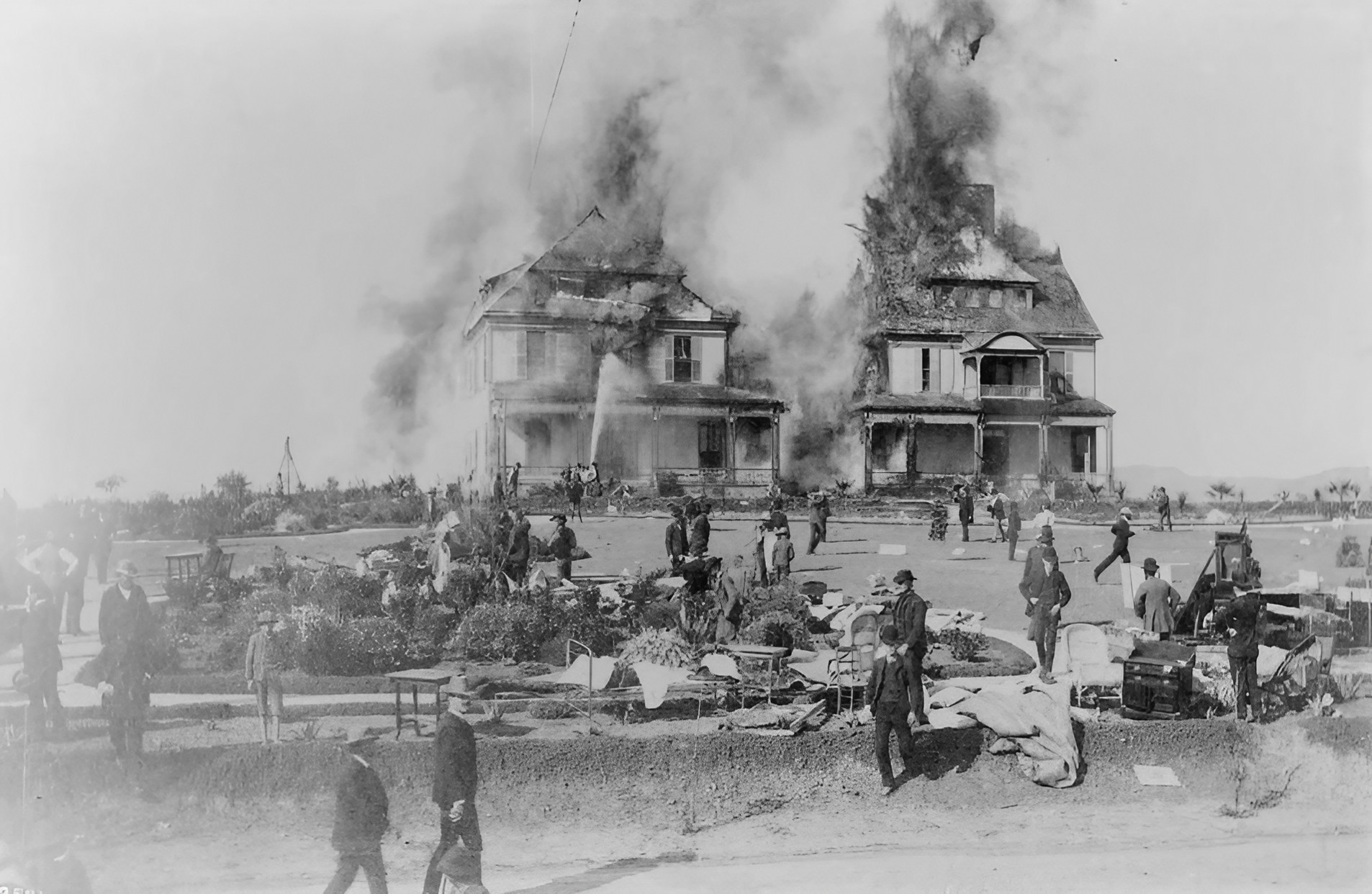
| (1887)* - The Belmont Hotel on fire at the corner of Belmont Street and First Street, December 16, 1887. While firemen hose down the hotel, people are shown milling around on the lawn which is covered with assorted sheets, furniture, etc. (This is the earliest photograph of a major fire in Los Angeles and possibly the earliest photo of the newly formed Los Angeles Fire Department in action.) |
Historical Notes On December 16, 1887, a fire broke out in the Belmont Hotel’s kitchen beneath the water tank. Engines struggled to reach the hilltop, detouring around Bunker Hill, and drew water from nearby Second Street Park. Within two hours the hotel was gone, a $50,000 loss. All sixty guests escaped safely, but the blaze exposed the city’s inadequate hydrants and fire planning. A photographer documented the event, producing what is believed to be the first image of a Los Angeles fire in progress. The Belmont was never rebuilt. Soon after, the property was reused by the Belmont School for Girls, which itself was destroyed by fire in the late 1880s. By the 1890s the ridge was dotted with oil wells and a pumping plant. In 1921 the Board of Education acquired the site, and Belmont High School opened in 1923, continuing the hill’s role as a civic landmark. |
 |
|
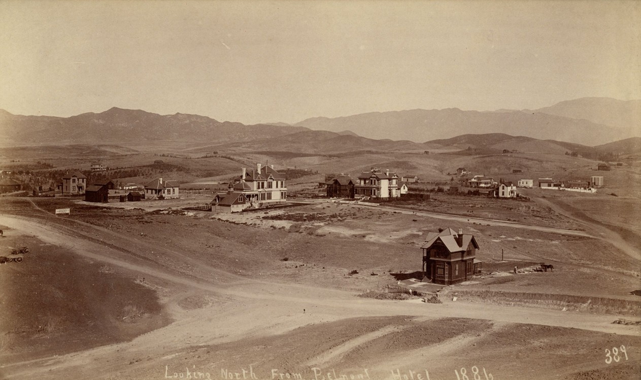
| (1886)* - View looking north from the Belmont Hotel. Residential homes can be seen across the rolling hillside. Photo by W. H. Fletcher. |
Historical Notes Looking north from the hotel, one sees widely spaced Victorian homes along the undulating terrain of Crown Hill. This view illustrates the neighborhood’s early suburban character—open land, scattered orchards, and distant mountains—all within walking distance of downtown thanks to the cable railway. |
 |
|
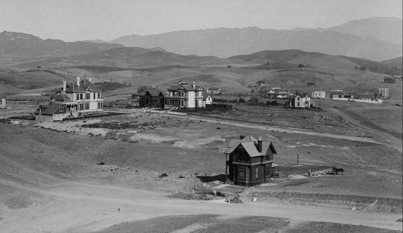
| (1886)* - Close-up view looking north from the Belmont Hotel. Residential homes can be seen across the rolling hillside. |
Historical Notes The view underscores how Crown Hill was marketed: a balance between fresh-air country living and city convenience. Buyers were promised elevated lots with vistas like these, though many of the tracts would soon give way to oil wells in the 1890s. |
 |
|
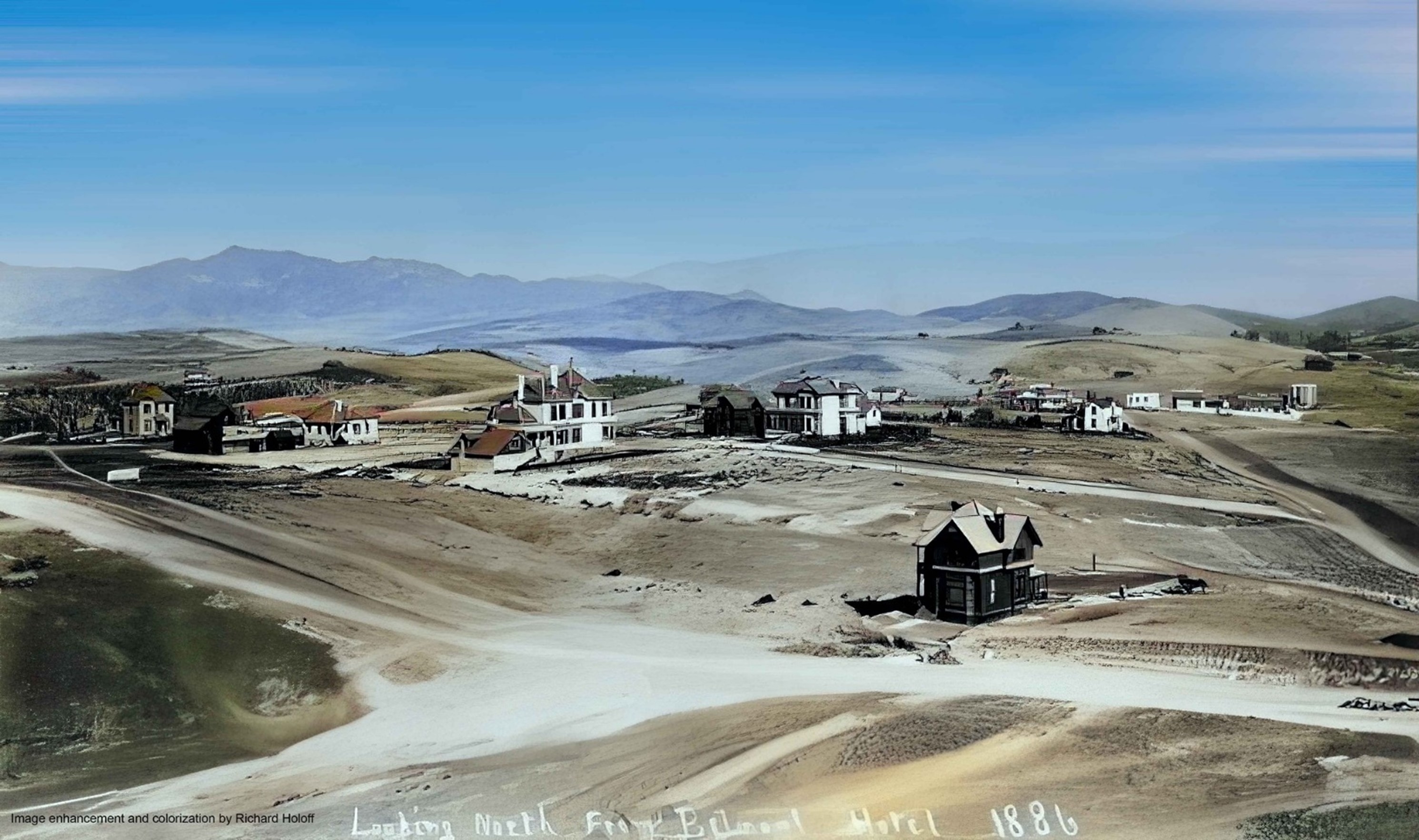
| (1886)* - View looking north from the Belmont Hotel. Residential homes can be seen across the rolling hillside. Photo by W. H. Fletcher; Image enhancement and colorization by Richard Holoff. |
Historical Notes Colorized to bring new life to the scene, this view shows the emerging suburb in its most pastoral moment—open hills, Victorian cottages, and unpaved roads. The promise of Crown Hill was short-lived, but photographs like this preserve the optimism of its early years. |
 |
|
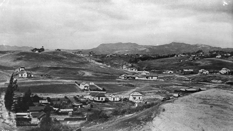
| (ca. 1886)* - Panoramic view of Los Angeles looking northwest on Third Street from Grand Avenue, showing the Belmont Hotel on top of Crown Hill. Houses are spaced widely apart on hilly terrain with mountains in the background. In the distance to the left, the building and spire of the Belmont Hotel is visible. The hotel was built in July 1886. The Hollywood HIlls can be seen in the background. |
Historical Notes The Belmont Hotel was the first major building to crown the hill that still bears its name. Here it appears like a beacon above scattered homes, its tower visible against the backdrop of the Hollywood Hills. Today, Belmont High School occupies this same site, continuing the landmark presence on the ridge. |
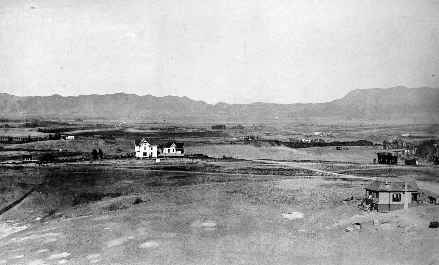 |
|
| (ca. 1886)* - View looking northwest from the Belmont Hotel showing several homes and a couple of dirt roads. The Hollywood Hills stand in the background. |
Historical Notes From the hotel’s verandas, visitors could look northwest toward the sparsely settled Hollywood Hills. This perspective highlights how quickly Los Angeles transformed—within a few decades these dirt tracks and open hills would be covered by oil wells, street grids, and dense residential development. |
Then and Now
|
|
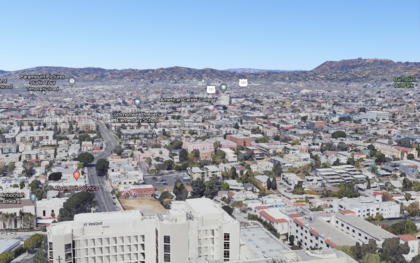 |
|
| (1886 vs. 2020) - Then and Now: View looking NW from near Belmont High School. Photo comparison by Jack Feldman. |
Historical Notes The 1886 view from the Belmont Hotel shows open fields, distant cottages, and the empty hills of Hollywood. The modern view, taken from near Belmont High School, reveals how completely the ridge and surrounding land were absorbed into Los Angeles’ urban grid. The site’s commanding views remain, but its pastoral character has long vanished. |
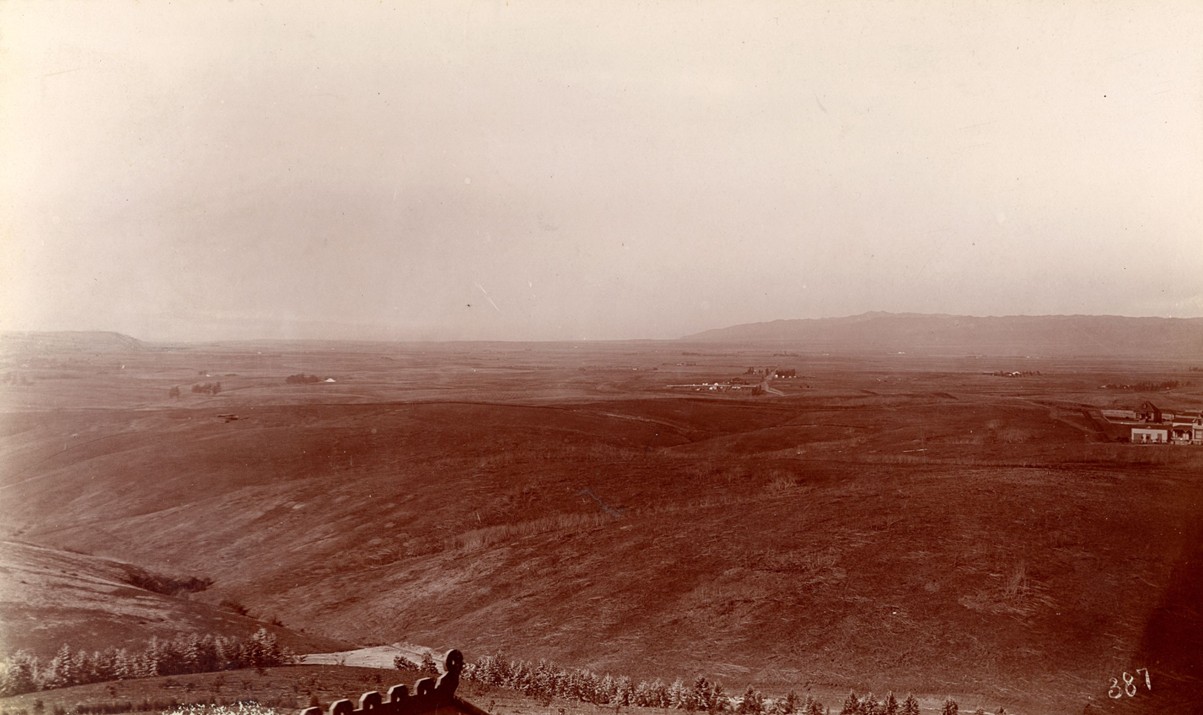 |
|
| (ca. 1886)* - View looking south from the roof of the Belmont Hotel located at Belmont and 2nd Street showing miles and miles of mostly undeveloped land as far as the eye can see. Photo by W. H. Fletcher. |
Historical Notes Looking south from the Belmont’s rooftop underscores how undeveloped Los Angeles remained in the mid-1880s. Vast stretches of farmland and orchards extended toward what would become Pico-Union and beyond. For hotel guests, the panorama symbolized the boundless possibilities of the growing city—landscape waiting to be filled by the boom. |
* * * * * |
Second Street Park
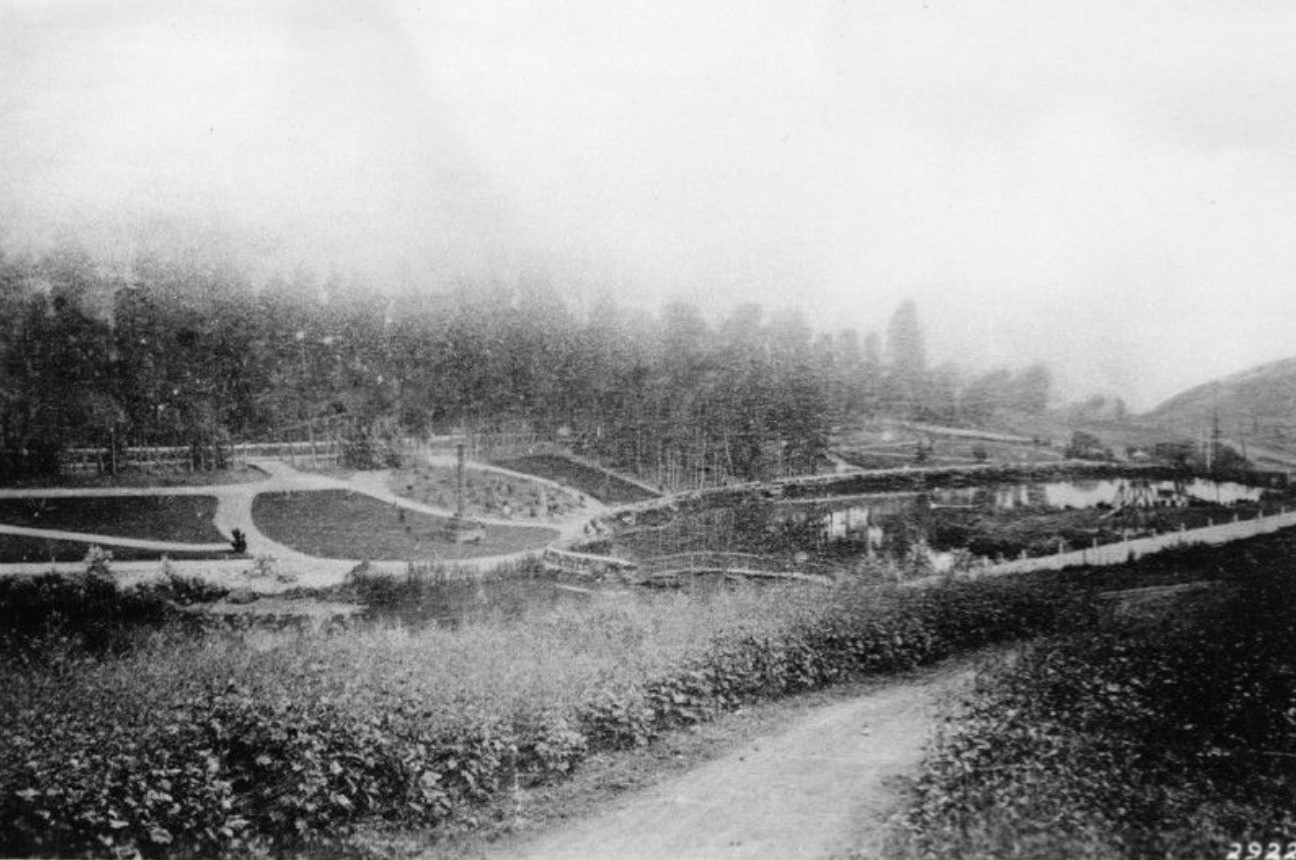 |
|
| (1887)* - View of Second Street Park, located on Diamond Street (later Beverly) and Lake Shore Avenue (later Glendale Blvd) near where 1st and 2nd streets merge today. |
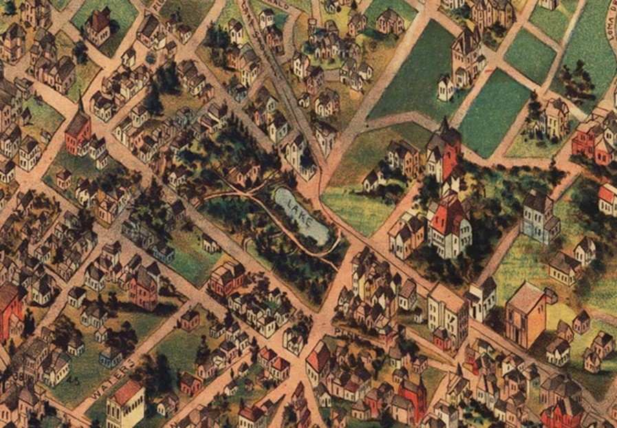
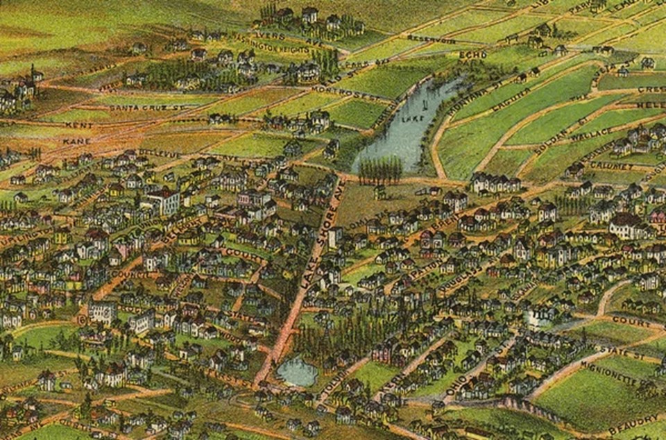
Historical Notes Located at the present-day intersection of Glendale Boulevard and First and Second streets, the park was part of an ambitious plan to transform what had been a remote, inaccessible wilderness into the upscale residential district of Crown Hill. Built around 1885 by the Los Angeles Improvement Company -- the real estate syndicate behind the Crown Hill development -- the park would attract potential customers to the site, which could be reached from Los Angeles by the Second Street Cable Railway. |
.jpg) |
|
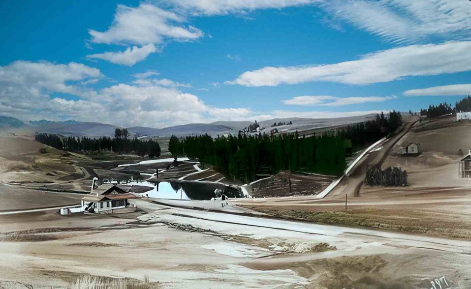
| (ca. 1890)* - View of Second Street Park and surrounding area which is nestled in the ravine of the Arroyo de los Reyes. |
Historical Notes Arroyo de los Reyes originates near the Catholic school on Glendale Boulevard – right by the 2 off-ramp. It flowed southward, along Glendale Boulevard, occupied the area now taken by Echo Park Lake, and continued down to 2nd Street, then crossing through downtown LA, about a block or two south of Pershing Square, where it spread and created a big muddy mess. These flows eventually connected with the Los Angeles River, when they didn’t seep into the ground first. |
 |
|
| (ca. 1890)^ - View of Second Street Park and surrounding area which is nestled in the ravine of the Arroyo de los Reyes. AI image enhancement and colorization by Richard Holoff |
 |
|
| (1891)^ - Second Street Park appears in the center of this detail from an 1891 map, courtesy of the Library of Congress. Note that north points toward the bottom of the map. |
 |
|
| (1894)*– Map showing Second Street Park and Lake located at the intersection of Lake Shore Ave (later Glendale Blvd) and 1st and 2nd streets (at lower-center). The larger Echo Park Lake is seen at upper-center, at the intersection of Bellevue Ave and Lake Shore Ave. Map courtesy of the Library of Congress. |
Historical Notes The Second Street Park's demise came quickly when the oil boom hit in the early 1890s and a forest of wooden derricks carpeted the neighborhood’s hills. Area residents would soon flock to two other nearby municipally owned parks, Westlake Park (opened in 1880) and Echo Park (1890). In the early 1900s, the private park was sold to a real estate syndicate led by Tyler & Co. and J. F. Jones. The syndicate filled in the former lake bed, graded the tract, and sold it off in 53 individual pieces. |
* * * * * |
Olive and 2nd Street
|
|
| (ca. 1885)* – View looking east on 2nd Street from Olive Street showing two cable cars of the Second Street Cable Railway at center. The First Presbyterian Church with its tall spire can be seen in the distance on the S/E corner of 2nd and Broadway. Further back is the copula of St. Vibiana's Cathedral on the east side of Main Street just south of 2nd Street. |
Historical Notes The Second Street Cable line began service with 80 trips per day, operating out of a power station and car house at Second and Boylston Streets. The line featured the steepest cable gradient in North America, a 27.7% slope between Hope Street and Bunker Hill Avenue. |
 |
|
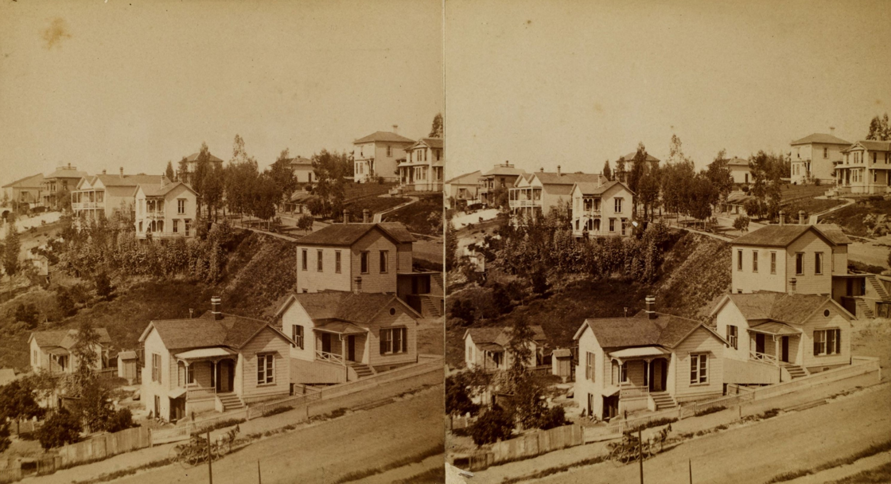
| (ca.1880)* - Stereoscopic view of houses on Second Street (in the foreground) and Olive Street (running perpendicular at upper right) in the Bunker Hill neighborhood of downtown Los Angeles. Photo from the Ernest Marquez Collection. |
Historical Notes Visible residences on Second Street include the matching one-story houses in the foreground: 426 West Second Street (with horse and wagon to its left) and, at right, 428 West Second Street (208 South Olive Street is visible directly next to 428 West Second). Visible residences on Olive Street include: 227 South Olive Street on the hill at far upper right with 235 South Olive Street directly to the left; across the street, towards center is 226 South Olive Street and the duplex behind it (with balconies running the length of both stories) is 230/232 South Olive Street. |
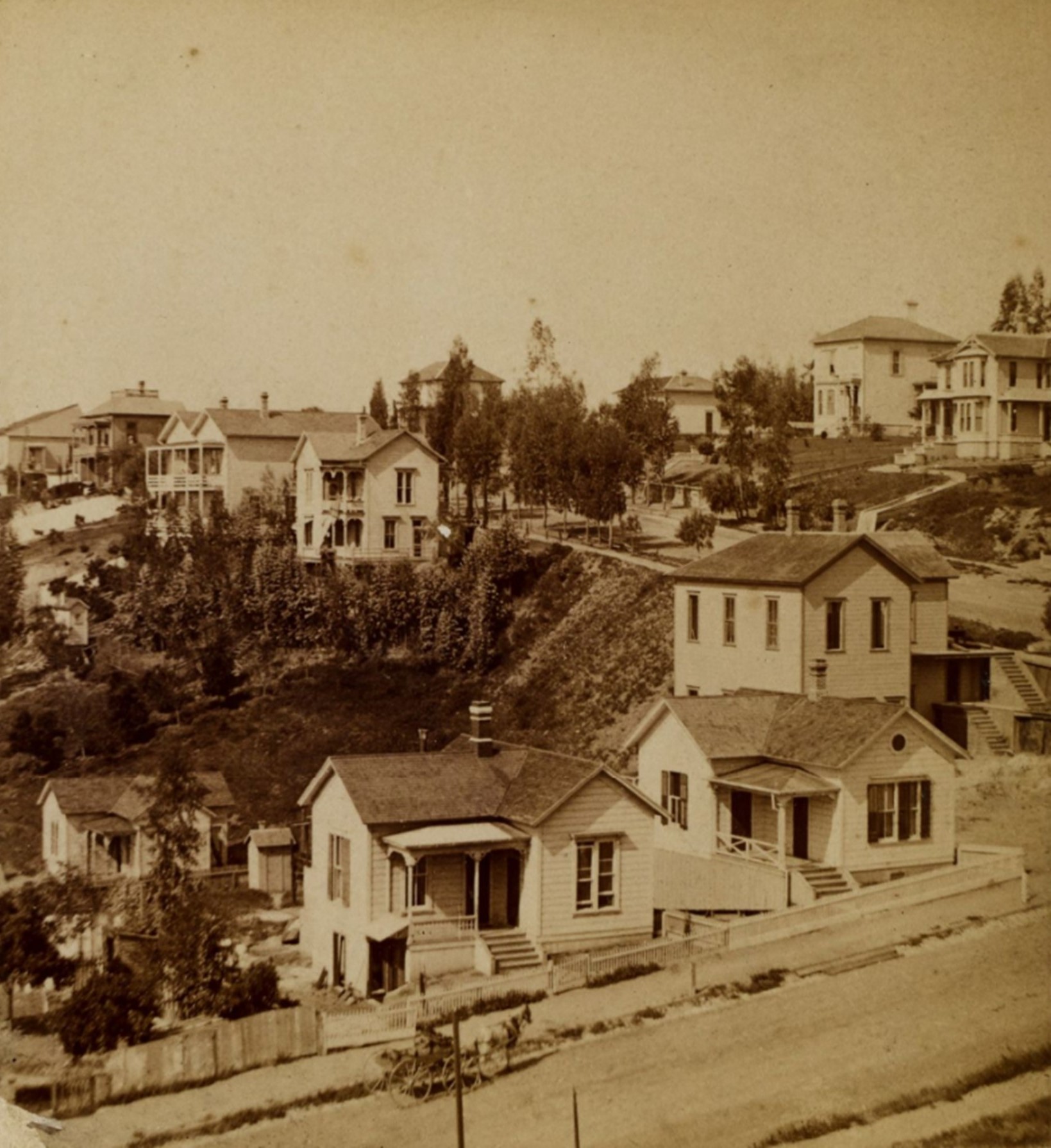 |
|
| (ca.1880)* - Looking southwest on Second Street (in the foreground) and Olive Street (running perpendicular at upper right) in the Bunker Hill neighborhood of downtown Los Angeles. Photo from the Ernest Marquez Collection. |
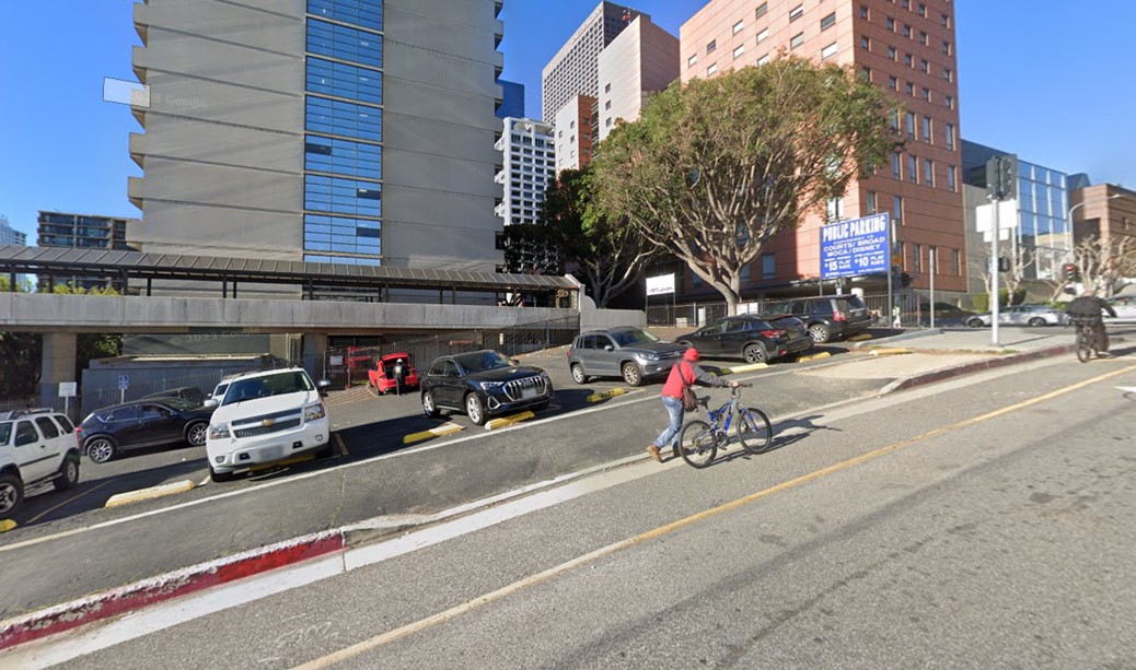
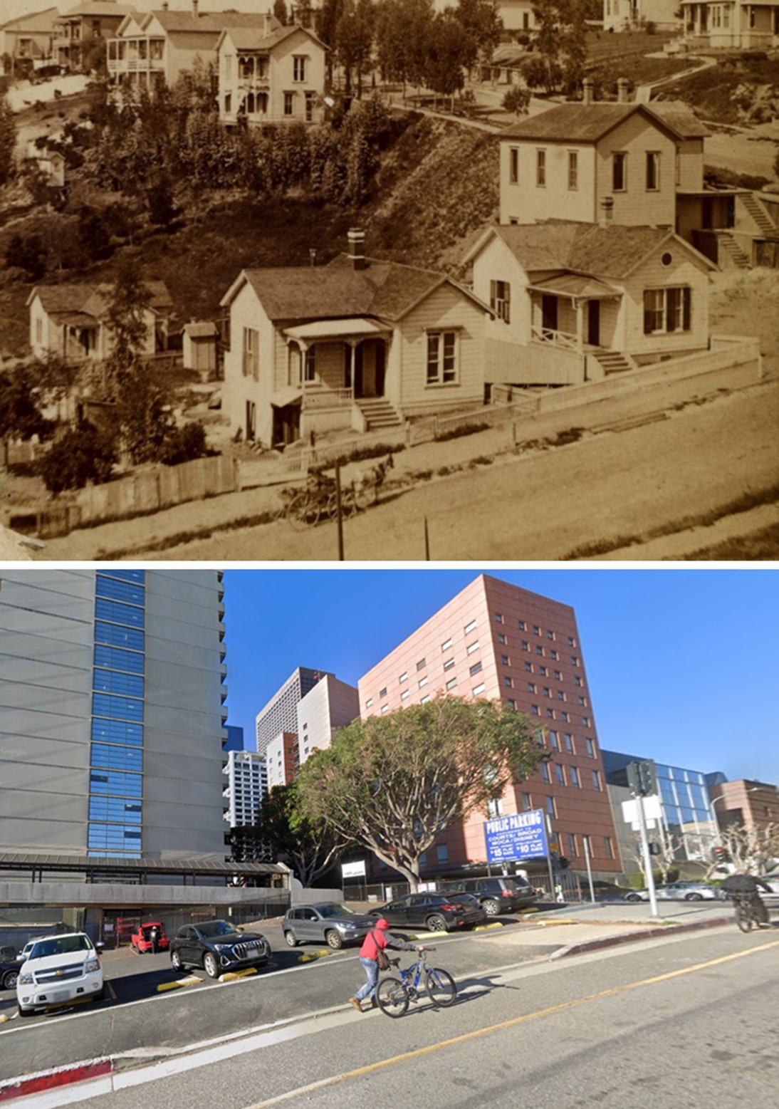
Historical Notes In the 1880s, Bunker Hill's steep slope along 2nd Street in Los Angeles posed significant challenges for transportation. To address this, the Second Street Cable Railway began operation in 1885, boasting the steepest cable car gradient in North America—a remarkable 27.7% incline between Hope Street and Bunker Hill Avenue. This incline was too steep for conventional vehicles or easy pedestrian access, making the cable car an essential link between downtown Los Angeles and the emerging residential and commercial developments atop Bunker Hill. |
 |
|
| (2023)* - Looking southwest along Second Street (foreground) and Olive Street (intersecting at the upper right) in Bunker Hill, a slope that remains a challenge for walking or biking. |
Then and Now
 |
|
| (1880 / 2023)* - Looking southwest along Second Street (foreground) and Olive Street (intersecting at the upper right) in Bunker Hill, where the steep slope has long posed challenges for walking, biking, and even horse-drawn carriages. Photo comparison by Jack Feldman. |
Then and Now
|
|
| (1885 vs. 2021)* - Looking east on 2nd Street from near Olive Street in downtown LA. Top photo shows two cable cars of the Second Street Cable Railway that ran over Bunker Hill. When comparing the Then and Now photos note that 2nd Street does not align exactly. That’s because in the 1920s a tunnel was bored under Bunker Hill (2nd Street Tunnel) which is located on the right below the parking lot. Photo comparison by Jack Feldman. |
* * * * * |
Grand and 2nd Street
 |
|
| (1886)^ - A view of Grand Avenue, south from 2nd in the year 1886. The right side of the street is lined with houses, hidden behind large trees. On the left side of the photograph, a horse-drawn carriage is seen mid-photo, and a half-wall, half-picket fence can be seen in the forefront, with a house barely visible behind trees and shrubbery. Grand Avenue is a long earthen road, and the sidewalks appear to also be unpaved. |
* * * * * |
Hill and Court Street
 |
|
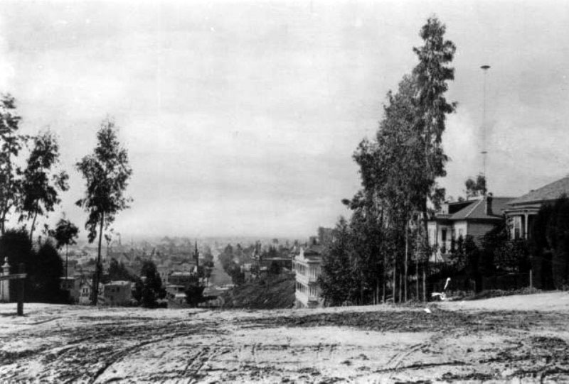
| (ca. 1886)^^ - View of Hill Street looking south from Court Street, showing an unpaved street and large homes (at right). Also at right is one of the City’s first electric streetlights. At 150-ft in height, it towers over all the surrounding homes. |
Historical Notes The white three-story building with balconies is the Highland Villa, located on the northwest corner of 1st and Hill streets. Approximately 30, 150-foot tall poles with carbon-arc lamps were installed in Downtown Los Angeles between 1882 and 1885. These were reported to provide illumination equal to the level of a full moon. Click HERE to see more in Early L.A. Streetlights. |
* * * * * |
Broadway and 1st Street
(Note: Broadway was known as 'Fort Street' until 1890)
 |
|
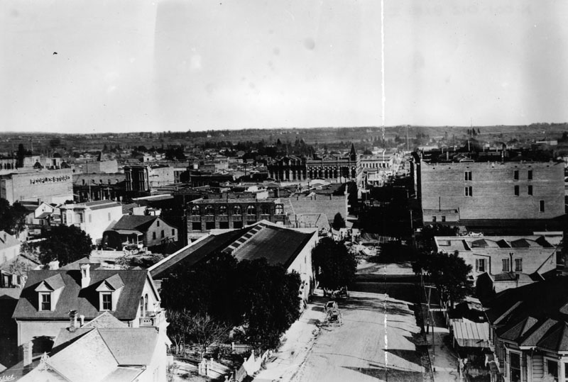
| (1886)^ - View looking east on 1st Street in 1886. At middle left, the Los Angeles Times Building is under construction on the northeast corner of 1st and Broadway. To its left on Broadway stands the People’s Store. |
Historical Notes This would become the second home of the Los Angeles Times, completed in 1887 after the paper left its original Temple Street office. The surrounding scene, still dotted with houses and small shops, shows downtown Los Angeles before Broadway was fully developed as the city’s main commercial artery. |
 |
|
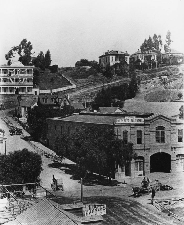
| (1886)* - The northwest corner of 1st and Broadway in 1886. Horses, carriages, and liveries dominated the scene, with the De Turk Livery Feed & Sale Stable occupying this corner. |
Historical Notes The De Turk Stable later became the Tally Ho Stables and eventually housed the first offices of the Los Angeles Chamber of Commerce. Across the street, excavation had already begun for the new Times Building, which would rise on the northeast corner the following year. At the upper-left, the 3-story building at the northwest corner of First and Hill is the Highland Villa. |
Then and Now
 |
|
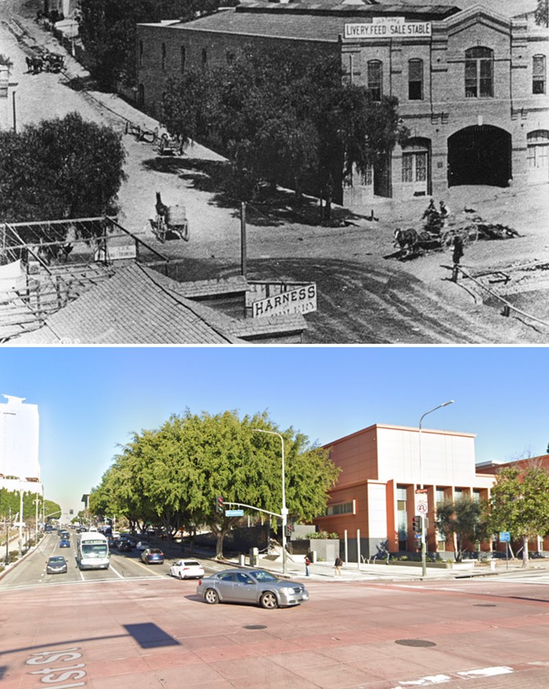
| (1886 vs 2023)* – Looking at the NW corner of Broadway and 1st streets. Photo comparison by Jack Feldman. |
Historical Notes What was once a dusty corner filled with stables and carriages has long since become part of Los Angeles’ dense Civic Center. The transition illustrates how quickly Broadway transformed from a frontier street into the city’s commercial and institutional heart. |
* * * * * |
LA Times Building (2nd Location)
 |
|
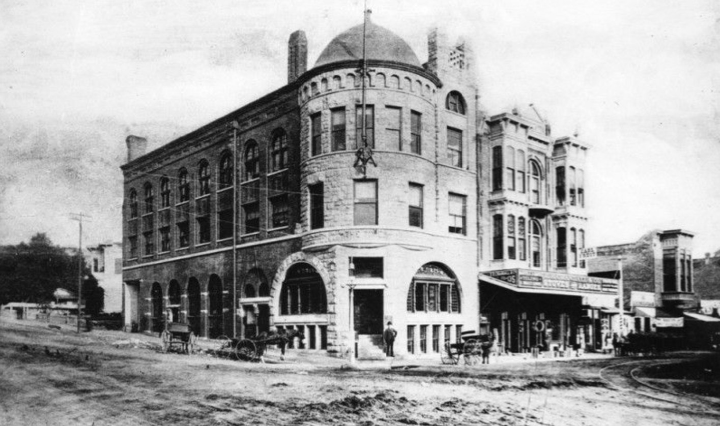
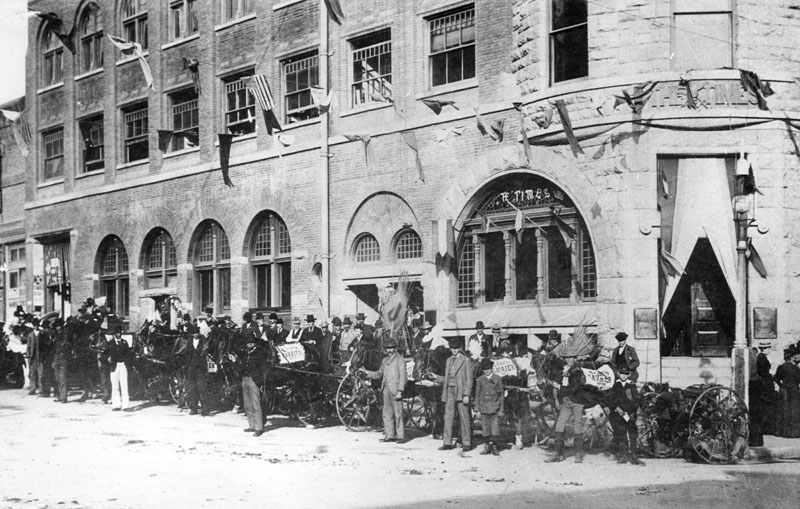
| (ca. 1887)* - The Los Angeles Times Building at its second location, completed in 1887, on the northeast corner of 1st and Broadway. The adjoining building to the right housed the Los Angeles Chamber of Commerce from 1889 to 1890. Click HERE to see the 1st Los Angeles Times Building. |
Historical Notes Publisher Harrison Gray Otis had taken control of the struggling Daily Times in 1884 and reorganized it as the Times-Mirror Company. Under his leadership, the paper became a powerful voice for business and development. The building symbolized the Times’ new influence, though it would also become a target of labor tensions, culminating in its destruction during the 1910 bombing. |
 |
|
| (ca. 1887)^ - Los Angeles Times carriers gathered outside the new Times Building at 1st and Broadway. |
Historical Notes By the late 1880s, the Times was expanding rapidly, and its circulation depended heavily on young carriers like these. Their presence underscored the growing reach of the paper at a time when Los Angeles was transforming into a major American city. |
 |
|
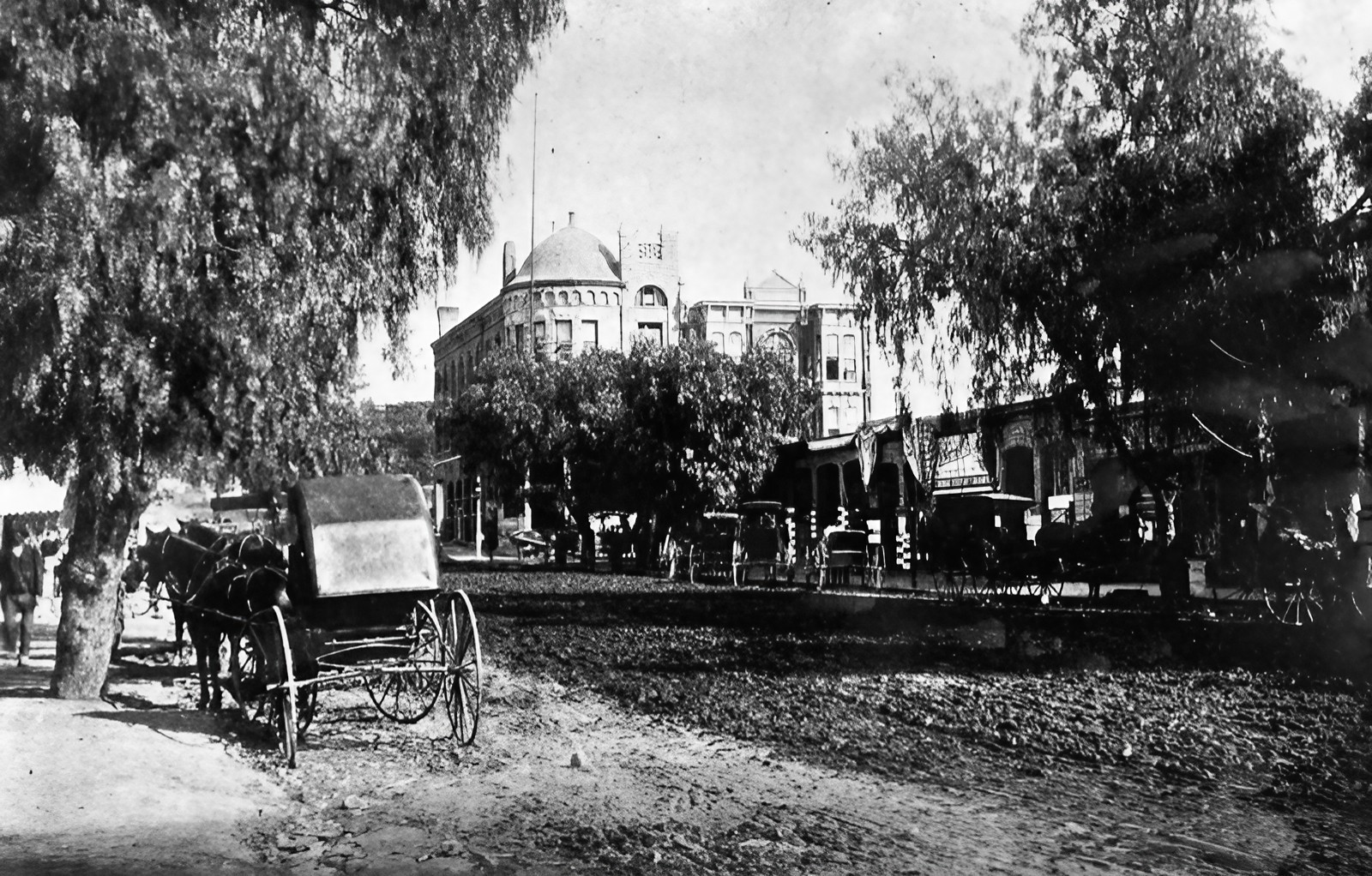
| (1888)* - Looking north up Broadway (formerly Fort Street) toward 1st Street. On the northeast corner stands the Los Angeles Times Building, completed in 1887. |
Historical Notes The building quickly became a landmark, representing both the city’s journalistic ambitions and its growth into a modern metropolis. Just north of the Times, the Chamber of Commerce reinforced the block’s civic importance. At this time, Broadway was still unpaved, but within a decade it would be lined with streetcars and become the city’s busiest commercial corridor. |
 |
|
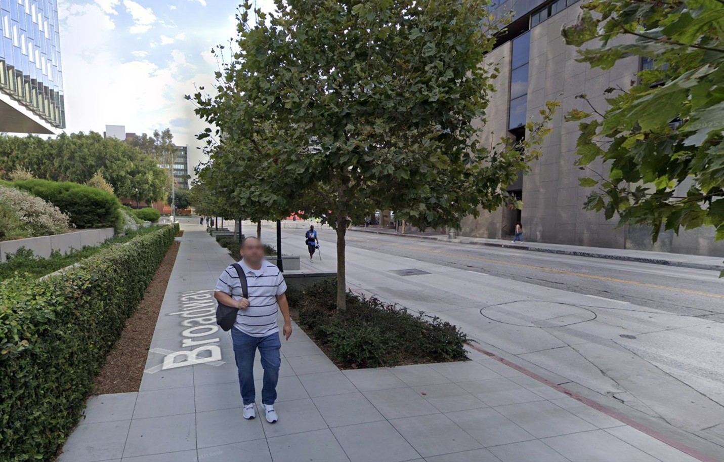
| (2024)* - Looking north on the Broadway toward 1st Street in downtown Los Angeles. |
Historical Notes The northeast corner where the Times Building once stood is now vacant and awaiting redevelopment. Across the street, the southeast corner was part of the Times Mirror Square complex, vacated by the newspaper in 2018 and now owned by the Onni Group. On the southwest corner stands the First Street U.S. Courthouse, opened in 2016. Today, the intersection reflects both the legacy of the Times and the ongoing reshaping of downtown’s Civic Center. |
Then and Now
 |
|
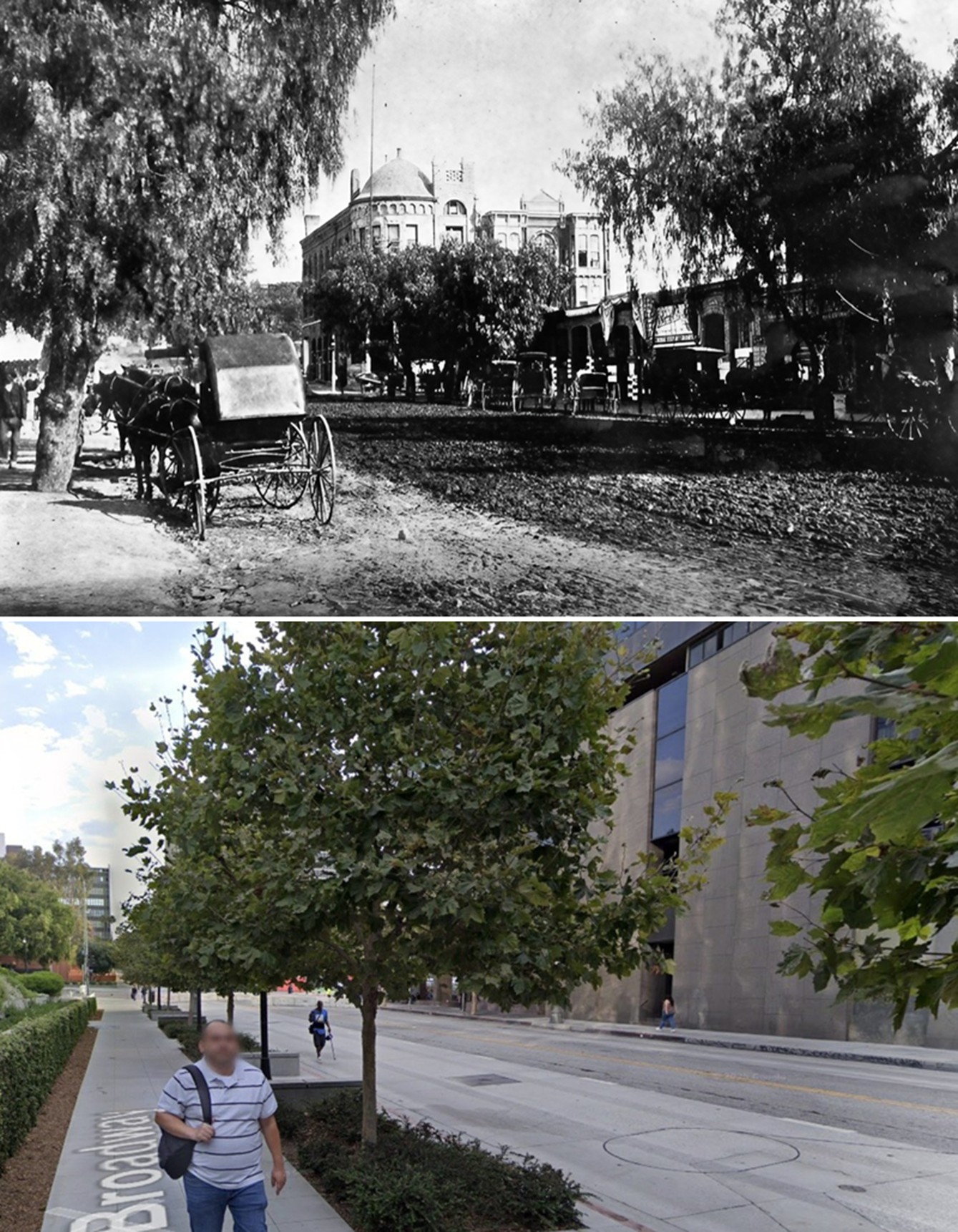
| (1888 vs. 2024)* - Then-and-now views looking north on Broadway toward 1st Street, 1888 vs. 2024. The site of the second Los Angeles Times Building is now an empty lot. Photo comparison by Jack Feldman. |
Historical Notes In 1888, the Times Building was a proud symbol of the city’s rise; today the same corner awaits its next chapter. The shift from a bustling center of news and commerce to an idle lot underscores the cycles of growth and decline in downtown Los Angeles. |
Then and Now
 |
|
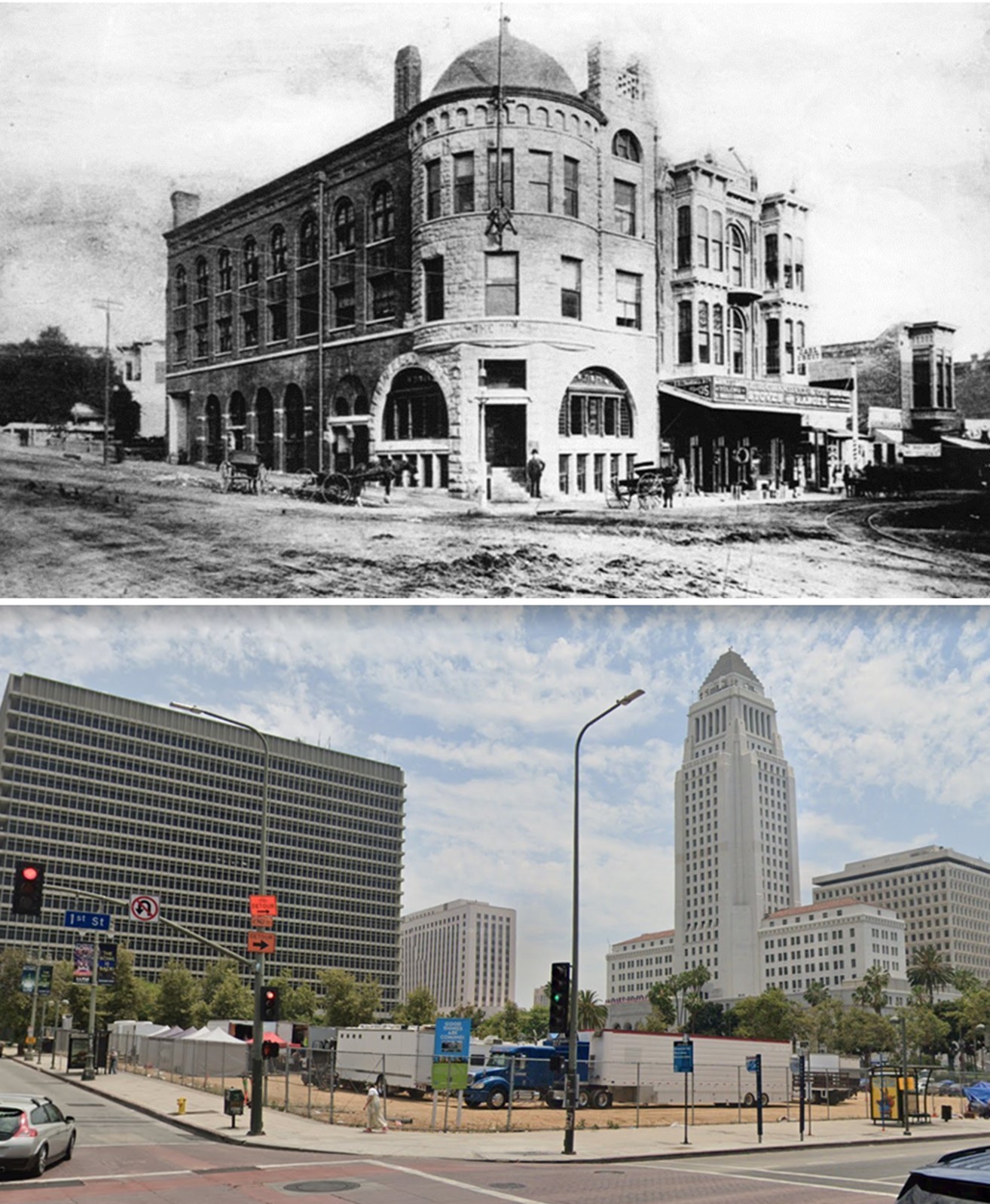
| (1887 vs 2021)* – Looking at the northeast corner of Broadway and 1st Street. Once the site of the ornate second Times Building, today it remains an empty lot. Photo comparison by Jack Feldman. |
Historical Notes The contrast is striking: the bustling 1887 street scene—with its carriages and landmark architecture—versus today’s vacant parcel. After the bombing, two successive Times buildings rose here, but by the late 20th century the site was cleared again. Long proposed as the “First & Broadway Civic Center Park,” it remains empty as of 2024, a quiet reminder of the explosive history that once shook Los Angeles. |
 |
|
| (ca. 1888)^ - Panoramic view looking east on an unpaved 1st Street from near Hill Street. The first cross street is Broadway, where a streetcar is turning the corner hading south onto Broadway. The Times Building is on the northeast corner of 1st and Broadway, and the Tally Ho Stables is on the northwest corner. The Metropolitan Stables is at right, on the south side of 1st Street. St. Vibiana's Church steeple is in the right distance. |
Historical Notes The Times Building is visible on the northeast corner, with the Tally Ho Stables across on the northwest. On the south side of 1st Street stood the Metropolitan Stables, while in the distance the steeple of St. Vibiana’s Cathedral rose above the scene. Together, the image captures a transitional moment when stables, streetcars, churches, and newspapers coexisted in a rapidly modernizing downtown. |
 |
|
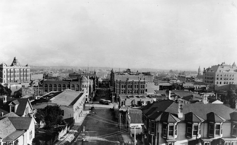
| (1886)^ - An unpaved 6th Street from Main Street, looking west in 1886. Spring is the first cross street shown. The State Normal School, is at far right on a hill, the later site of the Los Angeles Central Library. The area is mainly residential. |
 |
|
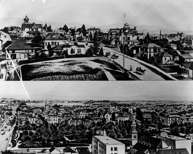
| (ca. 1880s)* - Two drawings of Los Angeles. The upper is of Bunker Hill, with street light, and the lower of Central Park (later called Pershing Square), looking east. |
Historical Notes The first electric street lights in Los Angeles were installed in 1882. Click HERE to see more in Early Los Angeles Street Lights. |
Hill and 11th Street
 |
|
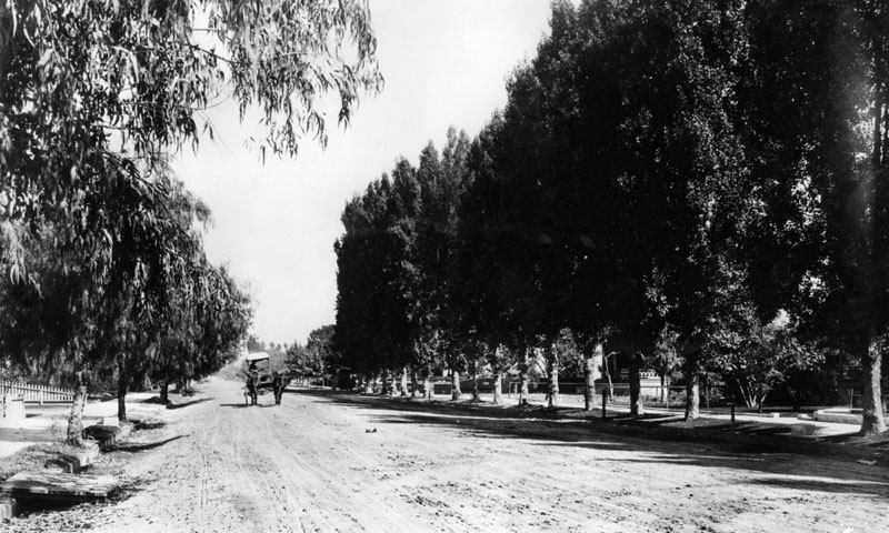
| (ca. 1880)^ - A horse and buggy plod down earthen, tree-lined Hill Street at Eleventh. Eucalyptus branches frame the photo on the left. |
* * * * * |
Compton
 |
|
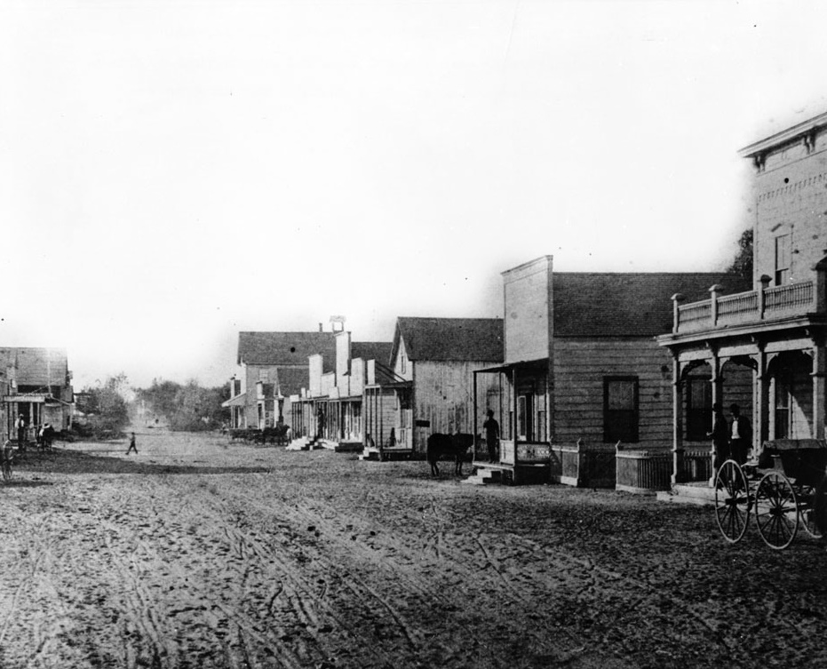
| (ca. 1885)* - View looking west on Compton Boulevard from Alameda Boulevard in Compton. |
Historical Notes In 1867, Griffith Dickenson Compton led about thirty pioneer families from Stockton to this area, seeking stable agricultural land after the decline of the Gold Rush. The settlement was first called Gibsonville, later Comptonville, and finally shortened to Compton to avoid confusion with the Comptonville located in Yuba County. |
.jpg) |
|
| (ca. 1885)^ - Horses and buggies standing in pooled stormwater along Compton Boulevard. |
Historical Notes Because Compton lay beside Compton Creek, a seasonal waterway feeding the Los Angeles River, the town frequently experienced flooding during heavy rains. |
 |
|
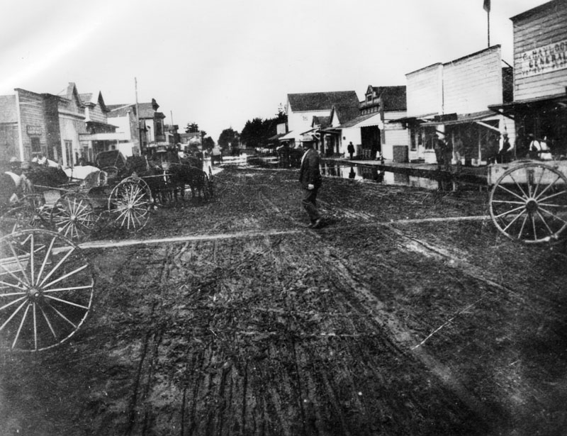
| (ca. 1888)* - A man crossing a muddy Compton Boulevard as horse-drawn wagons line the street. |
Historical Notes By 1887, residents pushed for stronger local governance. Griffith D. Compton donated land for incorporation, with the requirement that part of it be reserved exclusively for agriculture as Richland Farms. |
 |
|
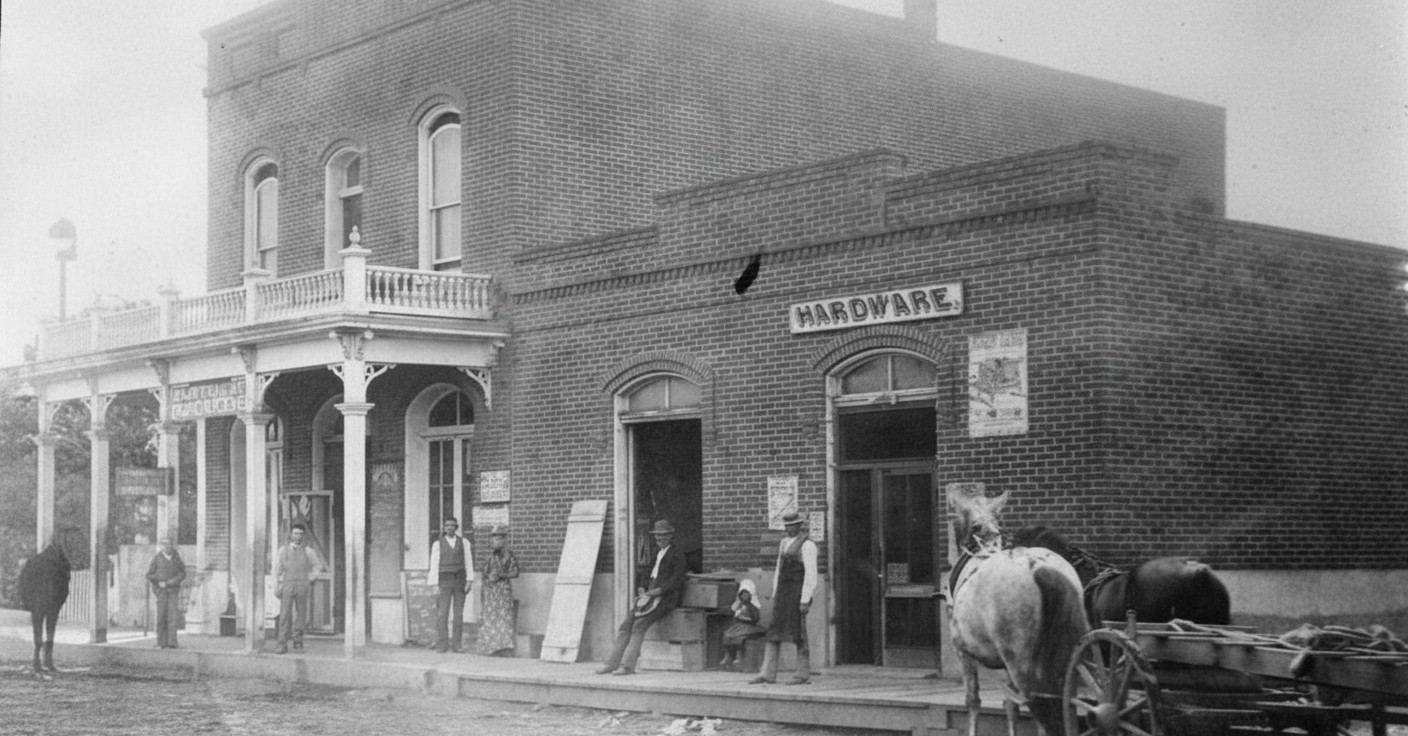
| (1887)* - View of Compton’s early business block, including a hardware store and grocery. Shop owners stand proudly in front of their brick buildings while a horse-drawn cart waits at right. |
Historical Notes Commercial activity in early Compton centered around a few essential businesses that served local farming families—hardware, general goods, blacksmithing, and food supplies. These early business blocks formed the core of what later became downtown Compton. |
 |
|
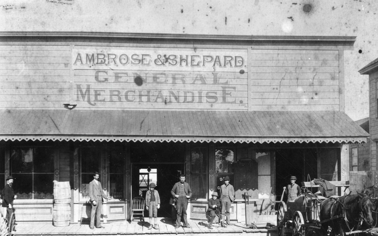
| (1890s)^ - Exterior of the Ambrose & Shepard General Merchandise Store in Compton. A horse-drawn buggy waits at right while owners and customers pose at the entrance. A young boy sits on his bicycle in the foreground. |
Historical Notes General merchandise stores like Ambrose & Shepard supplied clothing, tools, food staples, farming equipment, and household goods. These were vital one-stop shops for settlers before larger retail districts emerged. |
 |
|
| (1896)* - Men standing along the storefronts of the Haylock General Variety Store and the adjacent J.R. Hann Boots & Shoes. Other businesses line the street in the background. |
Historical Notes By the mid-1890s, Compton’s business district had expanded to include specialty shops such as boot makers, variety stores, repair shops, and dry goods merchants. This growing mix of businesses reflected Compton’s evolution from a rural farming community into an active small-town commercial center supporting both local residents and travelers. |
 |
|
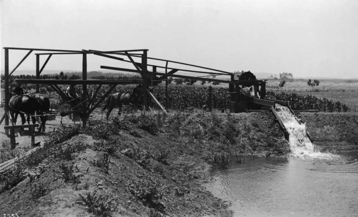
| (ca. 1890s)* - Four horses powering a mechanical irrigation device. Their movement turns a central pole connected to ropes that lift water into a reservoir used to irrigate surrounding fields in Compton. |
Historical Notes Horse-powered irrigation machines like this were common before electrification and were essential for farming in the region. They enabled farmers to reliably move water from creeks and shallow wells, sustaining crops during dry periods and supporting the area’s early agricultural economy. Click HERE to see more early views of Compton |
* * * * * |
Atchison, Topeka & Santa Fe Railway (Santa Fe Railway) - 2nd Transcontinental
 |
|
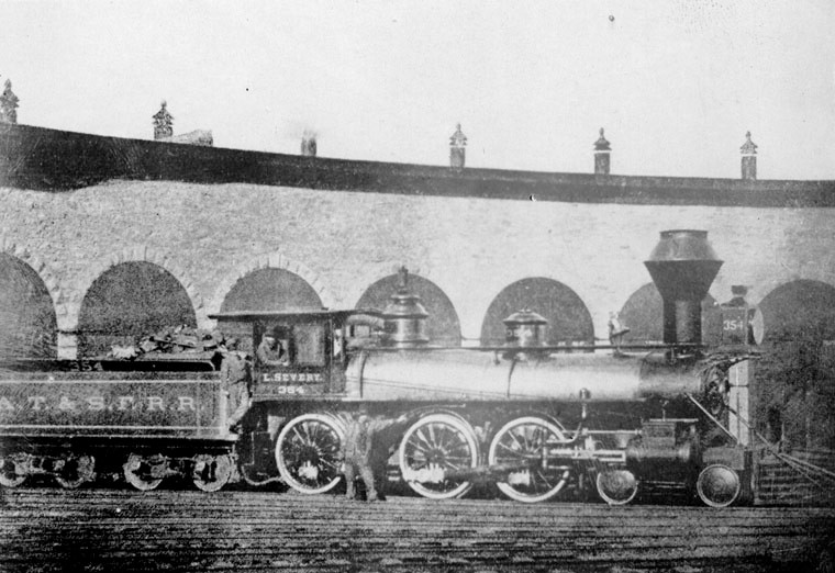
| (1885)^ - View showing the first Santa Fe locomotive engine to enter Los Angeles. |
Historical Notes When the Atchison, Topeka, and Santa Fe Railroad (aka Santa Fe) charted its own solo course across the continent in 1885 it chose Los Angeles as its western terminus, and in doing so fractured the Southern Pacific Railroad's near total monopoly on rail transportation within the state. The original purpose of this new line was to augment the route to San Diego, established three years prior as part of a joint venture with the California Southern Railroad, but the Santa Fe would subsequently be forced to all but abandon these inland tracks through the Temecula Canyon (due to constant washouts) and construct its Surf Line along the coast to maintain its exclusive ties to Los Angeles. |
 |
|
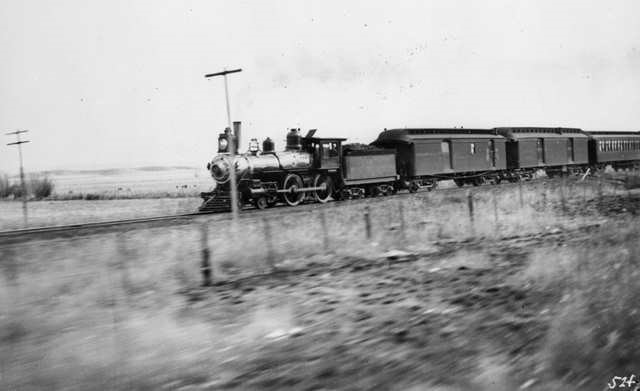
| (ca. 1895)*^ - Passenger Train of the Atchison, Topeka and Santa Fe Railway. |

Historical Notes Santa Fe's entry into Southern California resulted in widespread economic growth and ignited a fervent rate war with the Southern Pacific. It also led to Los Angeles' well-documented real estate "Boom of the Eighties." The Santa Fe Route led the way in passenger rate reductions (often referred to as "colonist fares") by, within a period of five months, lowering the price of a ticket from Kansas City, Missouri to Los Angeles from $125 to $15, and, on March 6, 1887 to a dollar! The Southern Pacific soon followed suit and the level of real estate speculation reached a new high, with "boom towns" springing up literally overnight. Free, daily railroad-sponsored excursions (complete with lunch and live entertainment) enticed overeager potential buyers to visit the many undeveloped properties firsthand and (hopefully) invest in the potential of the land. The Moorish-inspired La Grande railroad station was used as a passenger terminal for Atchison, Topeka and Santa Fe Railway. |
 |
|
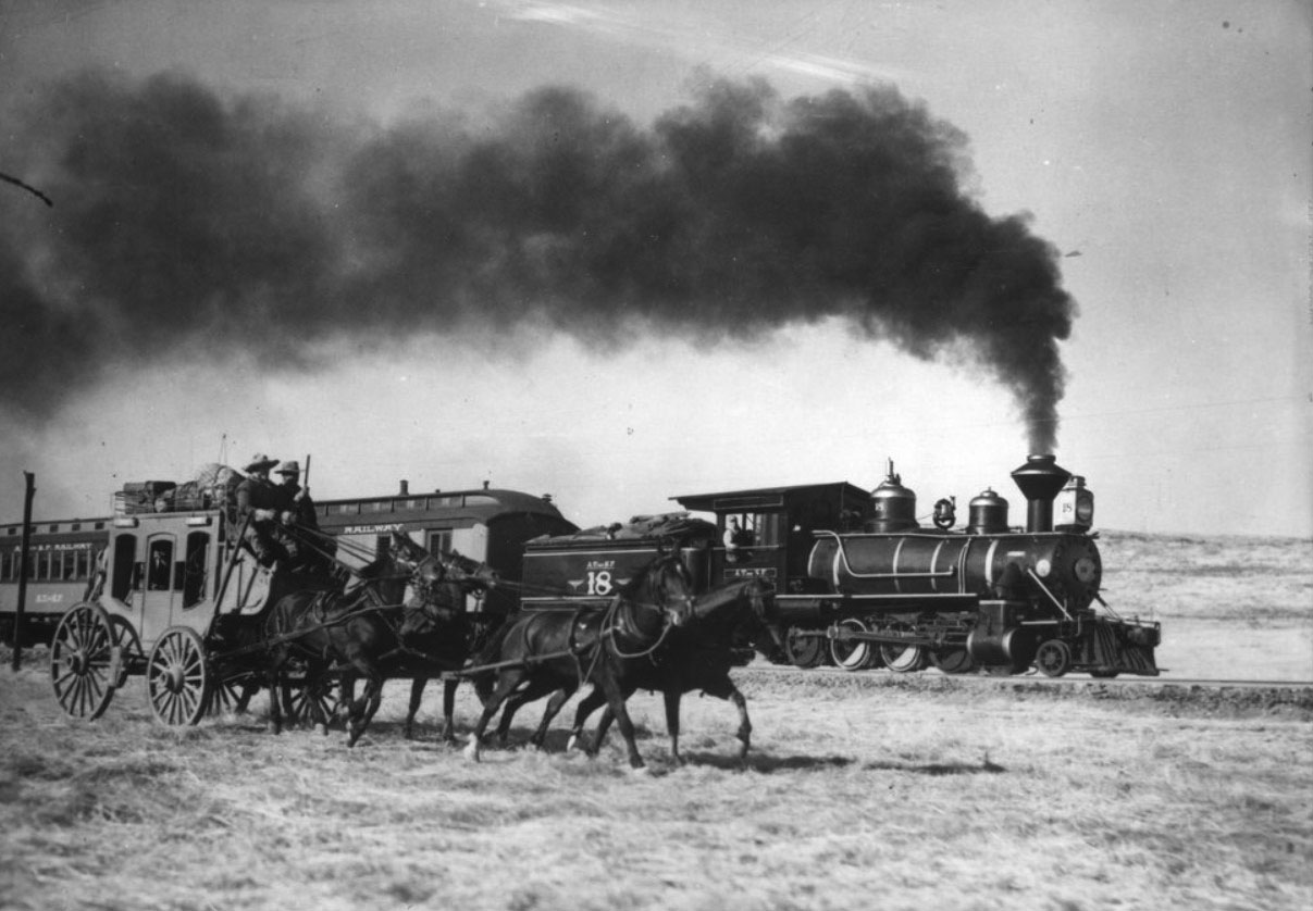
| (n.d.)+^^ – View showing the Atchison, Topeka & Santa Fe Railway locomotive #18 and a stagecoach. |
Historical Notes Major advertising campaigns by the SP, Santa Fe, Union Pacific, and other major carriers of the day not only helped transform southern California into a major tourist attraction but generated intense interest in exploiting the area's agricultural potential. Word of the abundant work opportunities, high wages, and the temperate and healthful California climate spread throughout the Midwestern United States, and led to an exodus from such states as Iowa, Indiana, and Kansas; although the real estate bubble "burst" in 1889 and most investors lost their all, the Southern California landscape was forever transformed by the many towns, farms, and citrus groves left in the wake of this event. |
* * * * * |
Cahuenga Valley Railroad
 |
|
| (1888)^ - Little steam engine and carriage of the Cahuenga Valley Railroad, which ran from Temple Street, Los Angeles, to Hollywood. Photograph is taken at Hollywood Boulevard and Wilcox Avenue. |
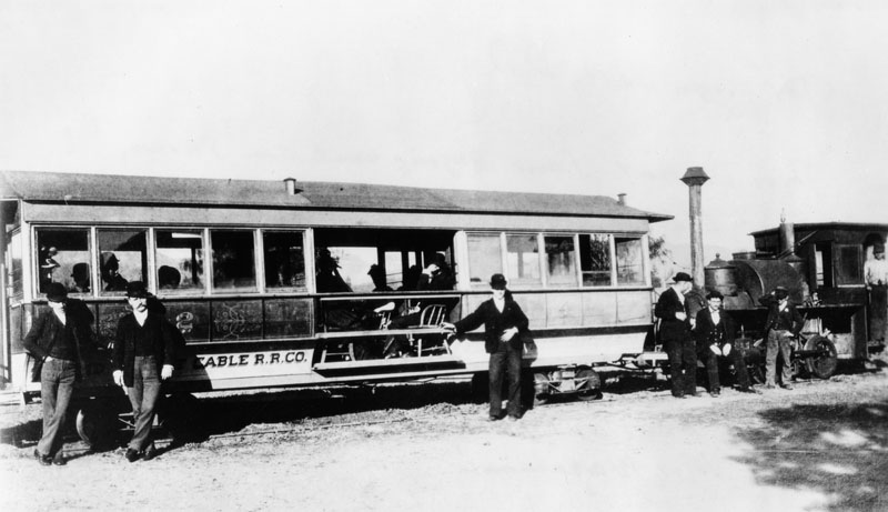 |
|
| (ca. 1880s)^ - In this photo the Cahuenga Valley Railroad line cable car is also called the "Dummy line." Note the inside of the cable car is actually hollow with wooden chairs being used for sitting. The Cahuenga Valley Railroad was a steam railroad built in the 1880's to provide access to Hollywood. Click HERE to see more in Early Views of Hollywood. |
* * * * * |
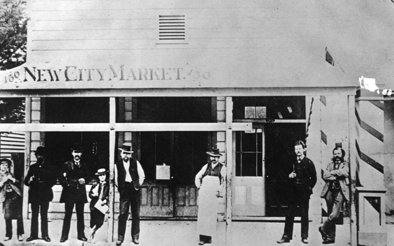 |
|
| (1887)^ - Several men and children stand posed outside the New City Market at 252 South Spring Street. |
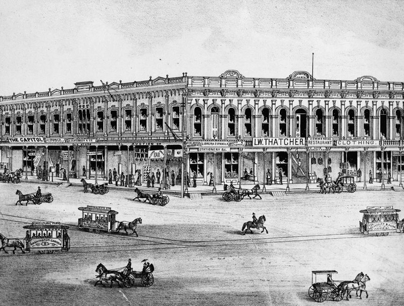 |
|
| (ca. 1880s)^ - Drawing of the Downey Block on the northwest corner of Main and Temple Streets. Various horse-drawn vehicles are seen on the street, including horse cars to Agricultural Park/Washington Garden, Spring & 6th Streets/S.P.R.R. Depot, and Boyle Heights/Los Angeles and Aliso Avenue/Perry Villa Tract. |
Historical Notes The Los Angeles Public Library was housed on the second floor of the Downey Block from 1872 to 1889. The Downey Block was demolished in 1904. Since then the corner has been the site of two Federal Buildings: the Federal Building and Post Office (1910 - 1937) and the Federal Courthouse and U.S. Post Office Building (1940 - Present). Horse-Drawn Streetcars remained the primary mode of public transportation through the 1880s, at their peak rolling through much of the booming city of Los Angeles. |
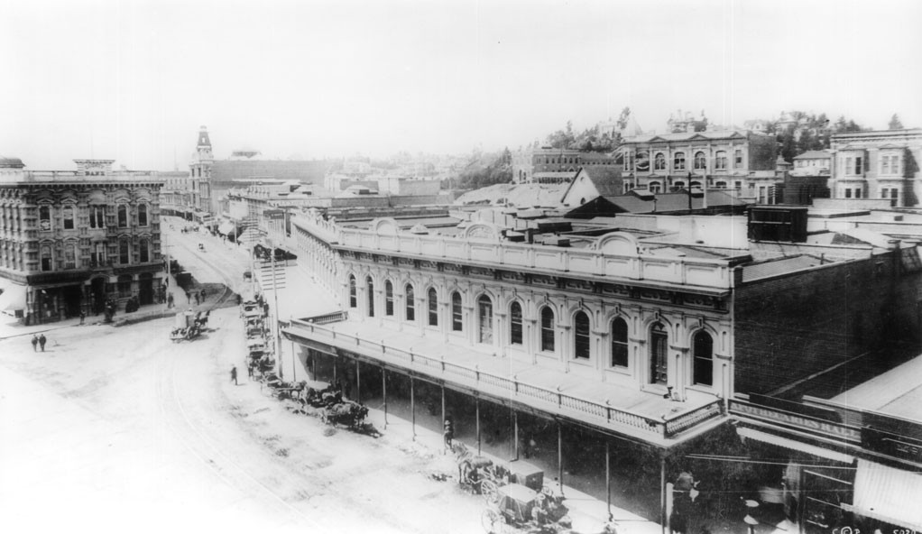 |
|
| (1887)^^ - View looking south on Main Street showing the Downey Block (right) on the N/W corner of Main and Temple. The Temple Block (current site of City Hall) is seen at left. A multitude of horse-drawn carriges and wagons are 'parked' along the curbs. |
 |
|
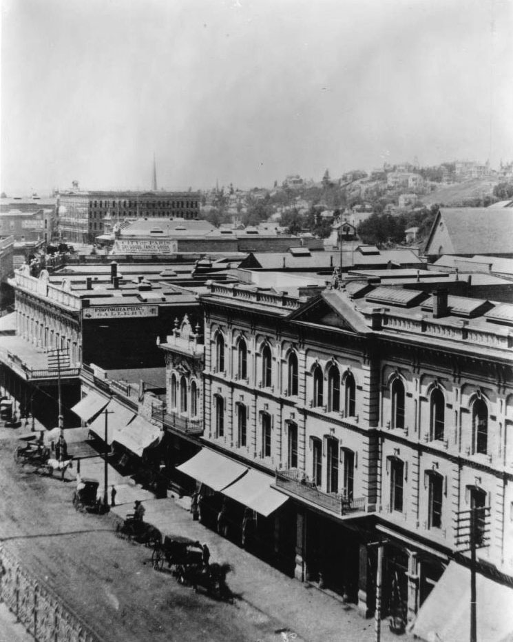
| (ca. 1888)^^ - View looking northeast showing the west side of Main Street. The Cosmopolitan Hotel (formerly the Lafayette Hotel; subsequently the St. Elmo Hotel) can be seen in the lower right corner. The Downey Block, on the northwest corner of Main and Temple streets, is seen at center-left. The structure with the triangular, peaked roof in the upper-right (above the Cosmopolitan Hotel) was built in 1864 as the St. Athanasius Episcopal Church; it was the first Protestant Church in Los Angeles located at the south-west corner of Temple and New High Streets. In the background, at left, the Nadeau Hotel (1882-1931) can be seen; it was located at the south-west corner of Spring and First Streets. Bunker Hill with houses and trees can be seen at upper-right. |
 |
|
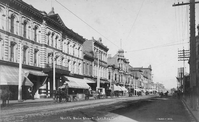
| (ca. 1890)* – View looking north on Main Street showing the Cosmopolitan Hotel at left. |
.jpg) |
|
| (ca. 1890)* - View showing the front of the Cosmopolitan Hotel (previously Lafayette Hotel) on Main Street. Note that the people standing on the sidewalk and front balcony appear to be posing for the photographer. |
First Electric Streetcars
 |
|
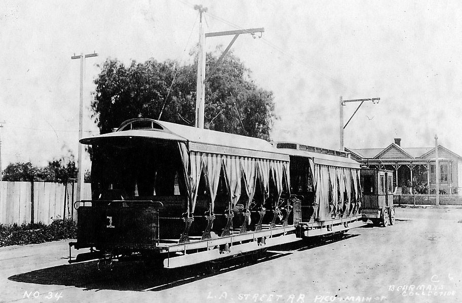
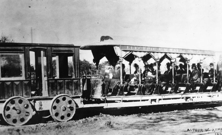
| (ca. 1887)^*# - Rear view of Los Angeles’ first electric streetcar at Pico and Main Street. Note the draped curtains on side of trolley. |
Historical Notes On September 11, 1886, Charles H. Howland chartered the Los Angeles Electric Railway Company. It began operations on January 4, 1887 with the line opening from Pico Boulevard and Main Street traveling west to Harvard Boulevard.*## |
 |
|
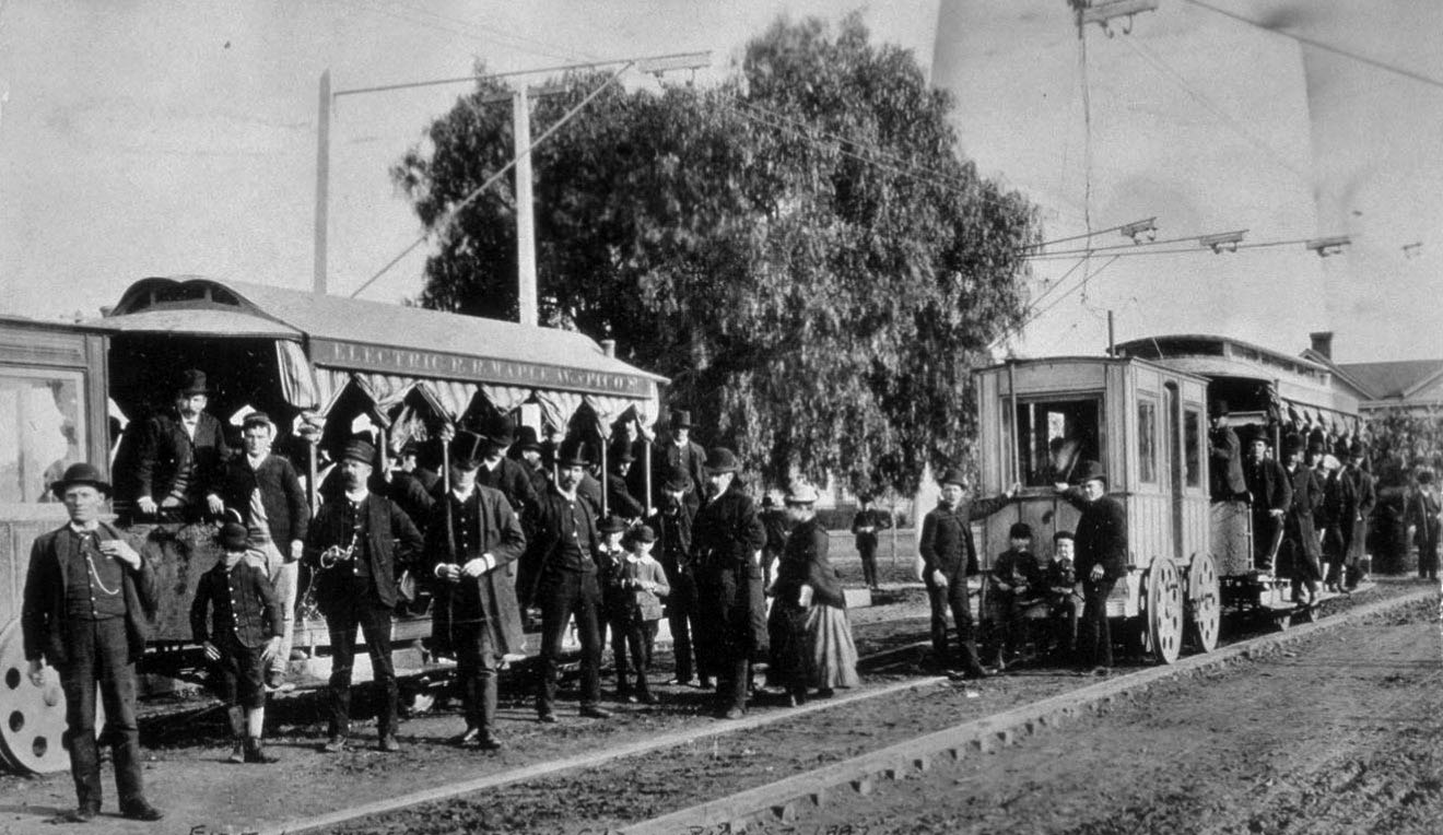
| (1887)#^*^ – Wide angle view showing well-dressed riders standing on and in front of two of the Los Angeles’ first electric streetcars on Pico Street. The sign on the side of the streetcar reads: “Electric R.R. – Maple Ave. – Pico St.” |
 |
|
| (1887)^ - View of the first electric trolley in Los Angeles as seen on Pico St. and Maple Avenue. The front car with its large wheels is pulling a trolley full of passengers. |
Historical Notes The first electric streetcars in Los Angeles began operating on the Los Angeles Electric Railway Company Pico Street line in January 1887. These cars used a two troller system designed by Leo Daft to get electricity from overhead wires. While the cars were capable of transporting people quickly, technical problems, breakdowns and delayed service were frequent. Following a powerhouse boiler explosion in June 1888, operation resumed with horse cars. Soon after the company declared bankruptcy.^^^* |
.jpg) |
|
| (1887)^ - View of the first electric car in Los Angeles, the G.O.P. line out Pico to Hoover Street. The trolley is filled to capacity with men standing on the runner board. |
Historical Notes In 1886, Charles H. Howland chartered the Los Angeles Electric Railway Company, L.A.'s 1st electric trolley system. Four years earlier (1882), he also built the first electric light power plant in Los Angeles, on the corner of Alameda and Banning Streets. |
* * * * * |
First Electric Power Plant
 |
|
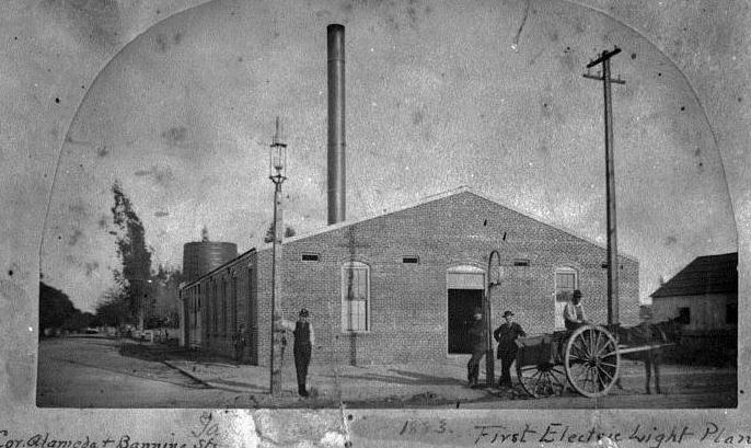
| (1883)* - Banning Street Electrical Plant -- The first electric light plant in Los Angeles was built in 1882 by Charles L. Howland on the corner of Alameda and Banning Street. Originally built to provide electricity for his new streetlights (LA's first electric streetlights), Howland would later expand the plant to provide power for his new streetcar company. Click HERE to see more in Early Los Angeles Streetlights. |
Historical Notes Charles Howland is also known for starting Los Angeles' first electric utililty, LA Electric Compnay, in 1883. That company would evolve to become LA Gas and Electric Corporation. In 1937, the electric side of LA Gas and Electric Corp. was bought out by the Los Angeles Department of Water and Power. The gas side of the company became Southern California Gas Company. Click HERE to see more in First Electricity in Los Angeles. |
 |
|
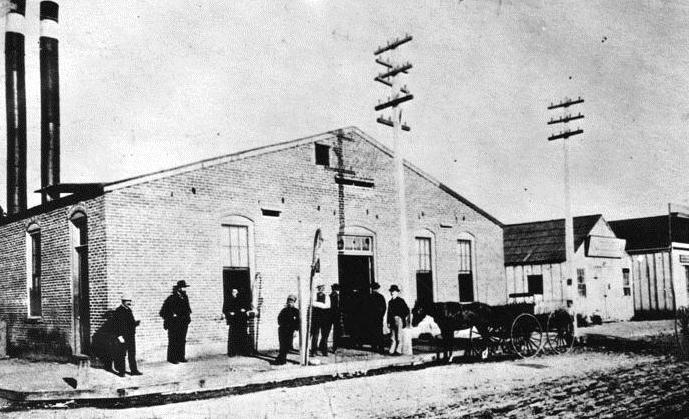
| (1888)* - Banning Street Electrical Plant now showing two smokestacks. The building as been enlarged from its original footprint as seen in the previous photo. Charles Howland built the power plant in 1882 and incorporated to become LA's first Electric Utility - LA Electric Company. |
Historical Notes Click HERE to see more in Early Power Generation. |
* * * * * |
Highland Park
 |
|
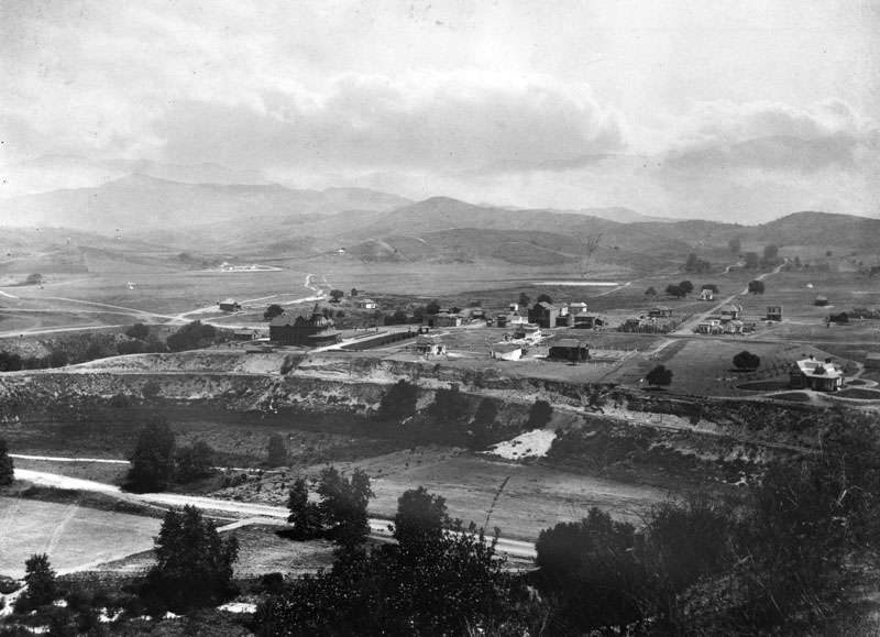
| (1887)^ - Panoramic view of Highland Park looking north in 1887. Garvanza was the north section of Highland Park. The Garvanza Hotel is the largest building in this picture (center-left). Arroyo Seco is in the foreground. In the right background is Johnson Lake; just below the lake is Miller's Hall. |
Historical Notes One of the oldest settled areas of Los Angeles, Highland Park is also one of the most scenic due to its location along the Arroyo Seco, between the Mt. Washington hills, the San Rafael hills and the Monterey Hills.*^ Garvanza is considered a sub-district of Highland Park. The area was named for the garbanzo beans that once flourished there. In 1899, Garvanza was annexed by the City of Los Angeles. |
 |
|
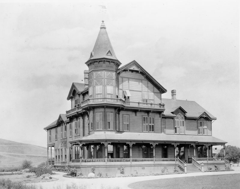
| (ca. 1886)^ - View showing the newly constructed Queen Anne revival style Garvanza Hotel. |
Historical Notes Opened in 1886, the hotel was located at South Avenue 63 and York Boulevard in Garvanza, a former section of Highland Park. |
* * * * * |
LA Plaza
 |
|
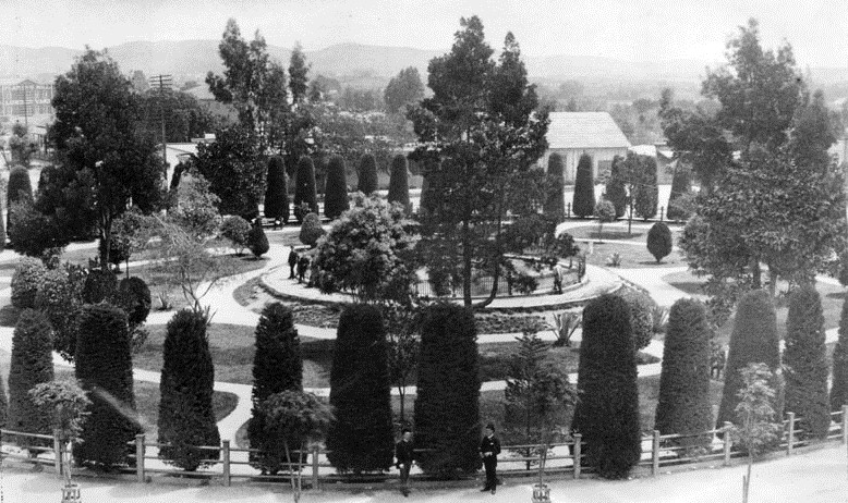
| (1886)^ - Los Angeles Plaza in 1886, looking northeast. Olvera Street is at extreme left. Note the landscaping around the Plaza and the degree to which it has grown. |
 |
|
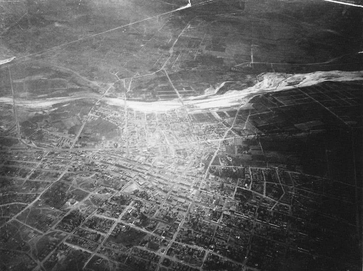
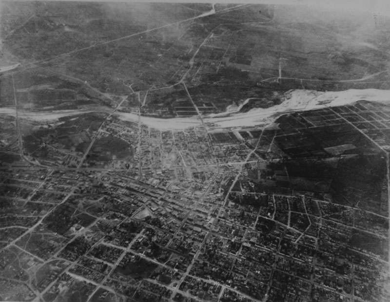
| (1887)* - Aerial photo of Los Angeles looking East on June 27, 1887 taken from a balloon. Note the farmland south of Second Street and east of Main Street to the Los Angeles River. The circular form of the Plaza is visible to the center left. |
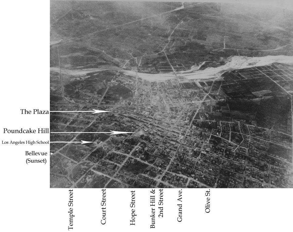
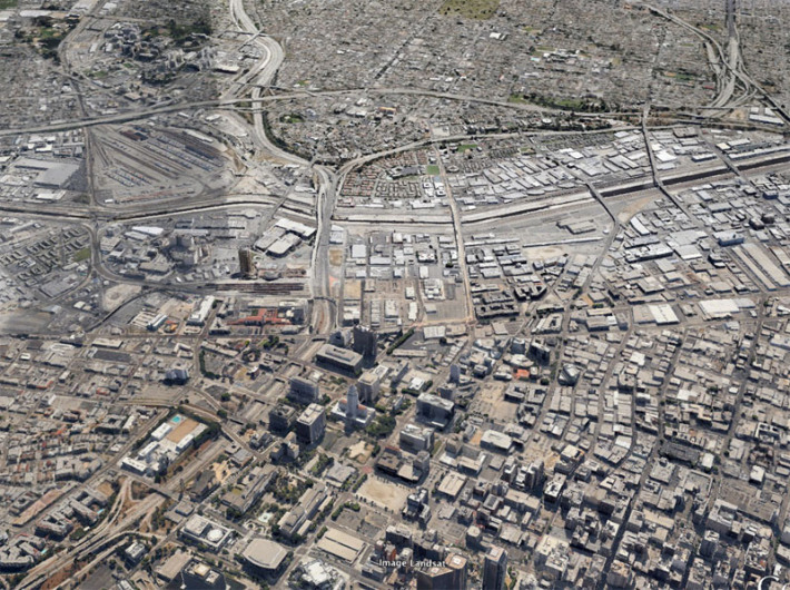
Historical Notes Floating some 9,000 feet above the city in a hot-air balloon in 1887, Edwin H. Husher took what may be the first aerial photo of Los Angeles. By 1887 the City's population had grown to over 20,000 people with most of the new development having taken place south of the orignal Pueblo and LA Plaza as seen in the above photo. |
 |
|
| (1887)** - Same photo as above but annotated to show the location of the Plaza and major streets. The circular form of the Plaza is visible to the center left. Note how the City has spread out mainly to the South of the Plaza. There is still a large area of farmland south of Second Street and east of Main Street to the Los Angeles River. |
 |
|
| (2013)* - Roughly the same view in 2013. Satellite imagery courtesy of Google Earth. |
Historical Notes In 1887, Los Angeles City's population: Approx. 20,000. In 2013, Los Angeles City's population: 3.9 million. |
Before and After
 |
|
| (1887 vs 2013)^ - Aerial view of Early Los Angeles - Population: 20,000 vs 4.0 Million |
 |
|
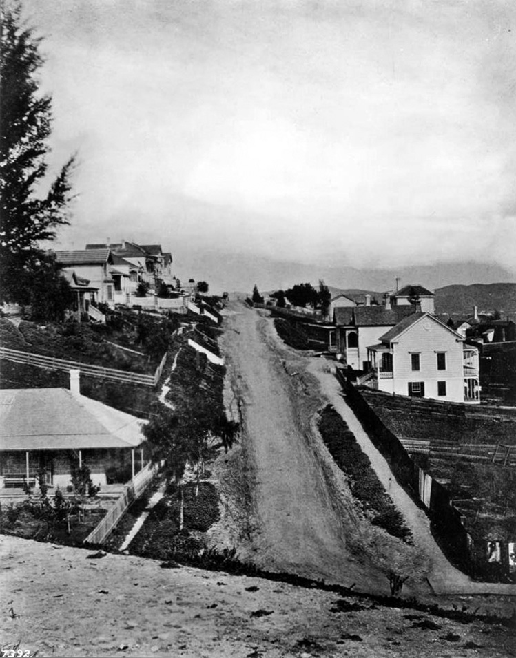
| (1880)* - View of Buena Vista Street, looking north from the school grounds on Fort Moore Hill. Buena Vista Street later became North Broadway. The adobe at left was used as a tearoom. |
 |
|
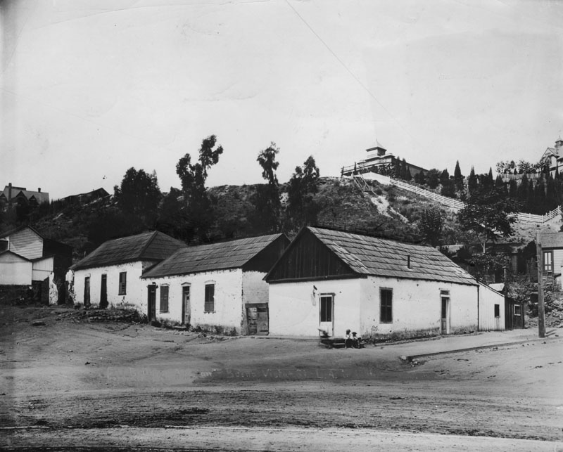
| (1886)^- The intersection of Bellevue Avenue and Buena Vista, looking southwest toward Fort Moore, when Los Angeles was a small town. Buena Vista Street was later renamed Broadway. The Banning House can be seen on top of the hill. |
Historical Notes This section of Buena Vista is soon to be renamed Justicia running south from Bellevue, which would become Sunset and then ultimately become Cesar E. Chavez Avenue (which here runs diagonally across the bottom of the frame from the lower left corner to the right edge) to Temple. Buena Vista north of Bellevue would become N. Broadway. The Broadway tunnel is still fifteen years in the future, the north portal of which will exit the base of the hill behind these adobes. Mary Hollister Banning's house can be seen on the crest of the hill. It will overlook the north portal. #^* |
 |
|
| (ca. 1887)^ - View of Fort Moore Hill, showing the home of Mary Hollister Banning (upper-center), widow of General Phineas Banning. Part of the trenches of old Fort Moore, built in 1846-1847, are visible in the upper left. The structure was originally built by Jacob Philippi as a beer hall, but Banning purchased and transformed it into a home. |
Historical Notes Fort Hill (also known as Fort Moore Hill) was a prominent hill overlooking the pueblo of Los Angeles. Its commanding view of the city made it a strategic location. Fort Moore was an historic U.S. Military Fort during the Mexican–American War. Its approximate location was at what is now the Hollywood Freeway near the intersection of North Hill Street and West Cesar Chavez Avenue, downtown. The hill on which it was built became known as Fort Moore Hill, most of which was removed in 1949 for construction of the freeway. The hill was located one block north of Temple Street and a short distance south of present day Cesar Chavez Avenue, between the Los Angeles Civic Center and Chinatown. The fort is now memorialized by the Fort Moore Pioneer Memorial, 451 North Hill Street.*^ |
 |
|
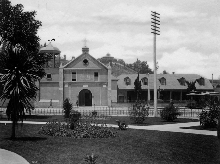
| (ca. 1887)^ - Exterior view of Plaza Church seen from the plaza, across the street. A trolley can be seen on the right side of the photo. In the background can be seen the Banning House sitting on top of Fort Moore Hill. |
.jpg) |
|
| (1888)^ - Horses and buggies at the Los Angeles Plaza in 1888. The California Bakery is seen in the background, as well as a covered wagon advertising the Home Ice Company. A horse and buggy in the foreground advertises for Bluett & Sullivan at 1st and Spring streets. The Banning Residence can be seen in the background on top of Fort Moore Hill overlooking the LA Plaza. Click HERE to see more in Early Plaza of L.A. |
 |
|
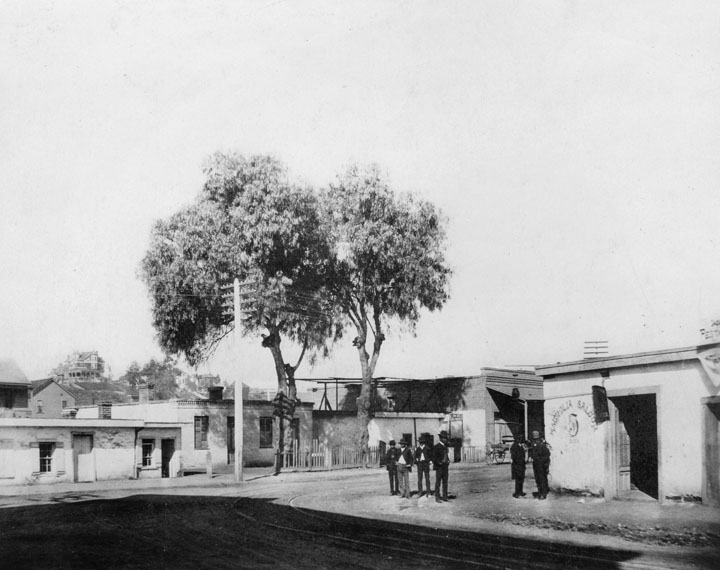
| (1888)^ - Men standing outside a saloon in Sonora Town at the corner of Bellevue and upper Main Street, which later was known as San Fernando Street and finally as North Spring Street. Adobes surround the intersection. On the hill in the background is the residence of J. W. Robinson, founder of the department store bearing his name. |
* * * * * |
Spring and 1st Street
 |
|
| (1880s)* - Looking south along Spring Street from 1st Street, this image captures an early Memorial Day—then called Decoration Day—parade in downtown Los Angeles. On the right stands the prominent four-story Nadeau Hotel at the southwest corner, while spectators, horse-drawn carriages, and uniformed marchers line the unpaved street. American flags hang in tribute, and the gathering reflects the city's growing civic pride in the post-Civil War era. |
Historical Notes Memorial Day originated as Decoration Day, established in 1868 by General John A. Logan and the Grand Army of the Republic to honor Union soldiers who died in the Civil War by decorating their graves. The first large observance took place at Arlington National Cemetery on May 30, a date chosen because it was not tied to any specific battle and flowers would be in bloom nationwide. Decoration Day quickly spread across Northern states, becoming an official holiday by the 1890s, while Southern states observed separate commemorations. After World War I, the holiday expanded to honor all American military personnel who died in service, and the name Memorial Day gradually replaced Decoration Day. In 1967, Memorial Day became the official name, and since 1971, it has been observed on the last Monday in May as a federal holiday marked by ceremonies and remembrance of fallen service members. |
 |
|
| (2021)* – Looking south on Spring Street at 1st Street. The LA Times Building stands on the southwest corner, the same site once occupied by the Nadeau Hotel, which stood there from 1882 until its demolition in 1932. |
Historical Notes Over the past 140 years, the view looking south on Spring Street at 1st Street in downtown Los Angeles has shifted from a dusty frontier town to a dense urban core. In the 1880s, the scene was marked by unpaved streets, horse-drawn carriages, wooden and brick storefronts, and a modest civic energy captured in parades and public gatherings. The Nadeau Hotel, Los Angeles’ first four-story building and an early symbol of the city’s ambitions, stood prominently on the southwest corner—an anchor of the era’s urban hopes. Today, that same corner is occupied by the LA Times Building, a monumental structure reflecting the city’s rise as a media and cultural powerhouse. The streetscape is now defined by tall glass and stone buildings, paved roads with marked crosswalks, traffic signals, and modern infrastructure—ranging from street furniture and landscaping to underground utilities. Yet amid these changes in scale, density, and technology, the original street grid and orientation remain intact, offering a rare and tangible connection between 19th-century Los Angeles and the metropolis it has become. |
 |
|
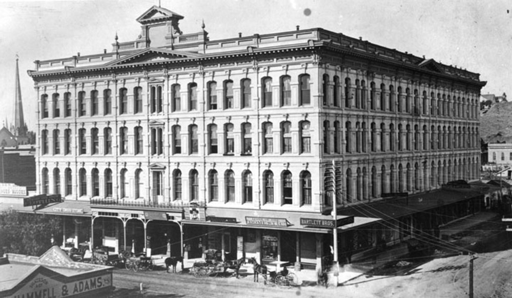
| (1886)* - View of the Nadeau Hotel on the southwest corner of Spring and 1st streets. A row of horses and carriages is lined up on the street in front. A tall spire of the First Presbyterian Church on Broadway (then Fort Street) and 2nd Street can be seen in the background on the far left. |
Historical Notes The Nadeau Hotel, located on the southwest corner of Spring and 1st Streets in downtown Los Angeles, was built in 1881-1882 by retired freighter Remi Nadeau. It was one of the city’s premier luxury hotels from 1882 until about 1900, rivaling the nearby Hollenbeck House. The hotel was notable as Los Angeles’s first four-story building and the first to feature an electric elevator, reflecting its modernity and status. Designed by architects Morgan & Walls, the Nadeau Hotel featured Italianate architectural details, including arched windows and decorative pediments, and housed numerous small businesses on its busy first floor. It became a central hub for businessmen, political leaders, and visiting celebrities. Remi Nadeau, who had amassed wealth through freighting and real estate, opened the hotel with a grand ball attended by the region’s elite. The hotel also implemented advanced amenities such as a steel dome hot-air furnace by 1897. The Nadeau Hotel stood as a landmark of the growing financial district in downtown Los Angeles until it was demolished in 1932 to make way for the current Los Angeles Times Building. Click HERE to see more on the Nadeau Hotel. |
 |
|
| (1888)* - The Odd Fellows' Conclave parade, looking north on Spring Street and 1st Street as seen from Nadeau Hotel. |
Historical Notes The Independent Order of Odd Fellows (IOOF), also known as the Order of Odd Fellows, is an international fraternal organization founded in 1819 that still exists today, with hundreds of thousands of members worldwide. The group is dedicated to principles of friendship, love, truth, and community service. Its "Communications" are formal conventions where members from various lodges gather to conduct official business, elect officers, coordinate charitable activities, and celebrate their fraternity—a tradition that continues in the present day. |
 |
|
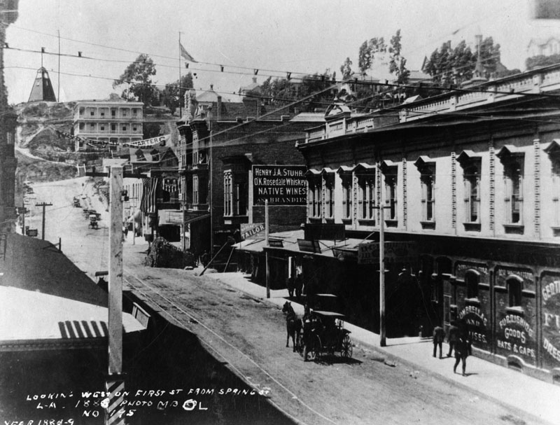
| (1888)^ - Looking west on 1st Street from Spring Street. The tower in the background is the general alarm tower of the fire department. The 3-story white building with the balconies is the Highland Villa, located on the northwest corner of 1st and Hill streets. |
 |
|
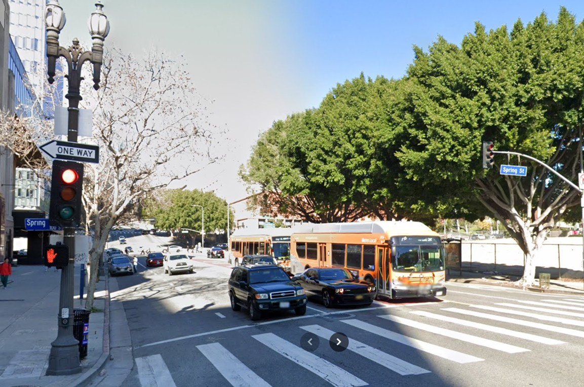
| (2023)* - Looking west on 1st Street at Spring Street in downtown Los Angeles. |
Then and Now
 |
|
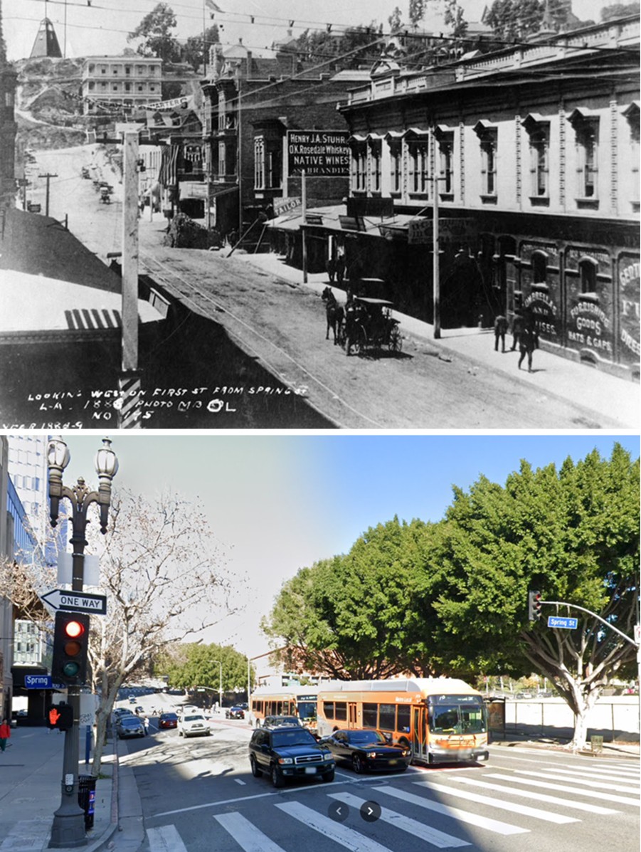
| (1888 - 2023)* - A ‘Then and Now’ comparison of 1st Street looking west at Spring Street. In the earlier photo, the tower in the background is the fire department’s general alarm tower, perched atop Bunker Hill. Photo comparison by Jack Feldman. |
 |
|
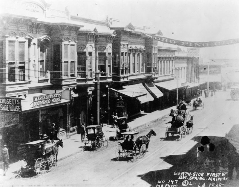
| (1888)^ - The north side of First Street between Spring and Main Streets in 1888. The Widney Building is on the left. |
Historical Notes Joseph Pomeroy Widney, M.D. D.D. LL.D (December 26, 1841 – July 4, 1938) was a physician, clergyman, entrepreneur-philanthropist, proto-environmentalist, prohibitionist, racial theorist, and prolific author. He at one time owned the Widney Block on First Street (near the corner of Temple and Spring Streets), another Widney Block located at Sixth between Hill and Broadway, and a property at the corner of Ninth and Santee streets, where he erected the Nazarene Methodist Episcopal Church. Additionally, he owned a building at 445–447 Aliso Street, where the first college of medicine for the University of Southern California was located from 1885 to 1896.*^ |
* * * * * |
Court and Main Streets
 |
|
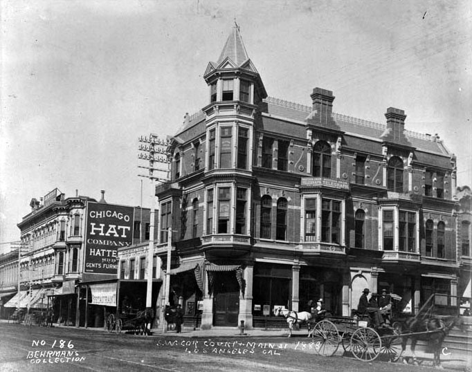
| (1888)^ - Southwest corner Court street and Main street; shows three-story Western Union Telegraph Company building with corner turret, chimneys and bay windows, address, 47 North Main Street; Chicago Hat Company at 35 North Main at left; horse-drawn carriages in street in foreground. On the right, behind the horse drawn wagon, can be seen stairs leading up to the Old Clocktower Courthouse. |
 |
|
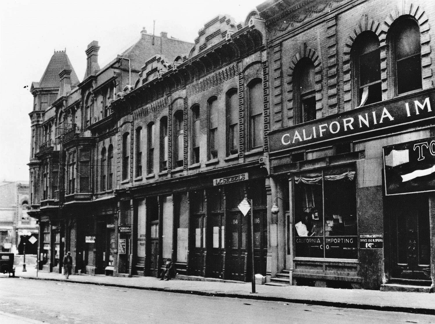
| (ca. 1920)* – View looking north on Court Street toward Main Street with the Western Union Telegraph Company building seen on the SW corner. |
* * * * * |
Main Street
 |
|
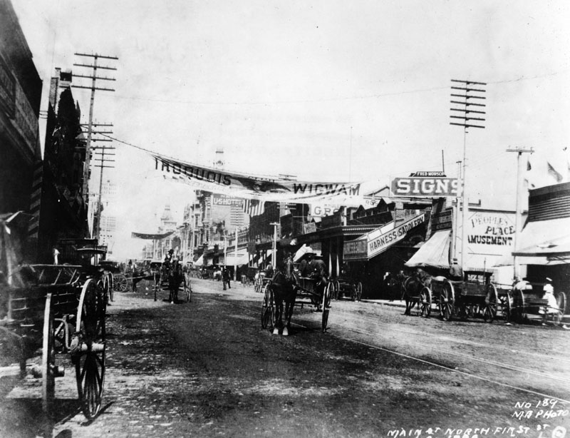
| (1888)^ - View looking north on Main Street near 1st Street. Horse-drawn carriages can be seen throughout. The Baker Block can be seen in the distance. |
 |
|
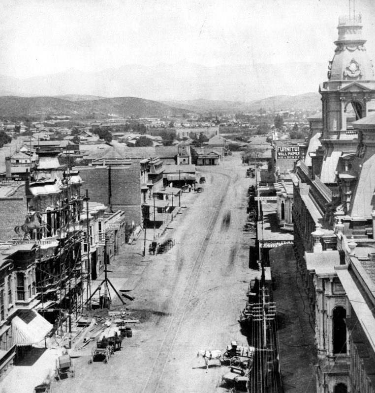
| (ca. 1887)^ - View looking north on Main Street from the Downey Building located just south of the Baker Block on the 300 block of N. Main Street. In the distance can be seen the Plaza Church where Main Street veers to the left. |
 |
|
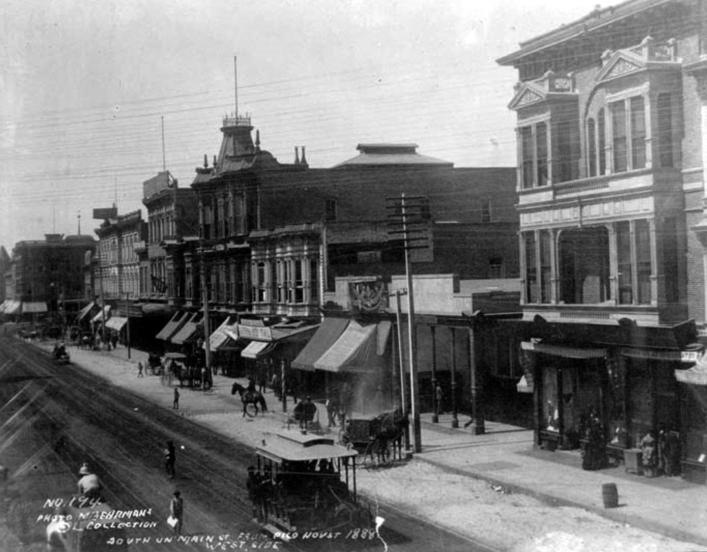
| (1888)* – View looking south on Main Street as seen from the Pico House. A horse-drawn streetcar shares the street with pedestrians, horse-drawn wagons, and a man on horseback (center-left). |
 |
|
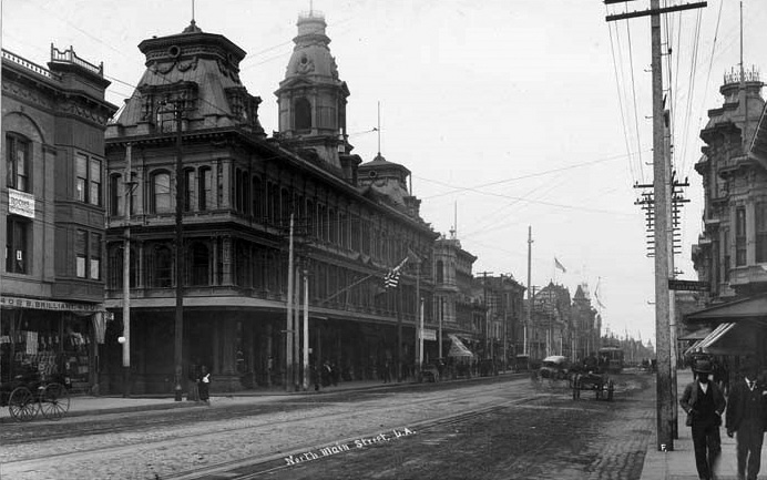
| (ca. 1890)* – View looking south showing the Baker Block and on the historic 300 block of N. Main Street. |
Historical Notes Click HERE to see more in Early Views of the Historic 300 Block of N. Main Street |
* * * * * |
City Hall (1884 - 1888)
 |
|
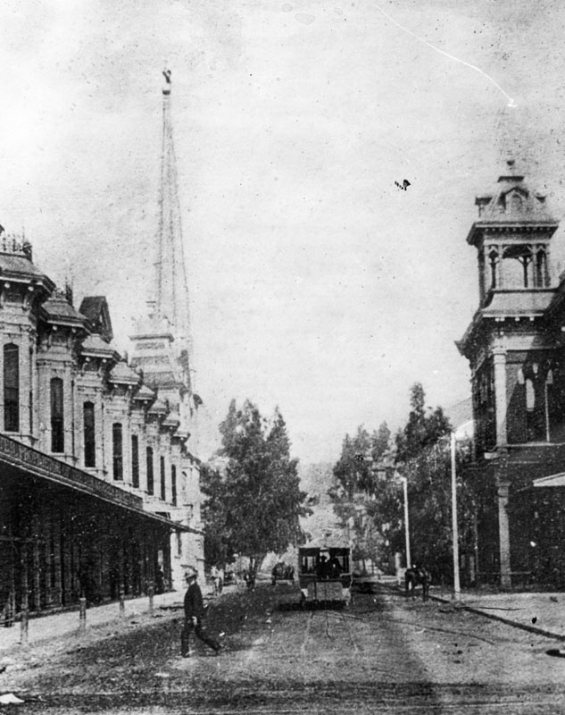
| (ca. 1886)^ - View looking west on 2nd Street from Spring Street. The building to the right was Los Angeles City Hall between 1884-1888 (site of current Los Angeles Times Building). Across the street is the Hollenbeck Block, with the First Presbyterian Church behind it on the southeast corner of 2nd and Fort Street (later Broadway). |
Historical Notes The following historical timeline lists the buildings used by City Council, also known as City Hall, since 1850, when Los Angeles was incorporated as a municipality: ◆ 1850 - 1853 - used rented hotel and other buildings for City meetings ◆ 1853 - rented adobe house (aka Rocha Adobe) on Spring Street - across from current City Hall (now parking lot for Clara Shortridge Foltz Criminal Justice Center). The buliding was shared with the County who used it as a Court House. ◆ 1861 - moved into John Temple's Clocktower Market Building, but only stayed for less than a year before the County Court House moved-in ◆ 1861 - 1884 - relocated back to the Rocha Adobe and stayed for over 20 years ◆ 1884 - 1888 - moved to new City Hall Building at South Spring Street and West 2nd Street (site of current Los Angeles Times Building) ◆ 1888 - 1928 - moved to new Romanesque Revival Building on 226-238 South Broadway between 2nd Street and 3rd Street; demolished in 1928 and now site of parking lot between LA Times Parking structure and 240 Broadway. ◆ 1928 - moved to current City Hall Building |
* * * * * |
City Hall (1888)
 |
|
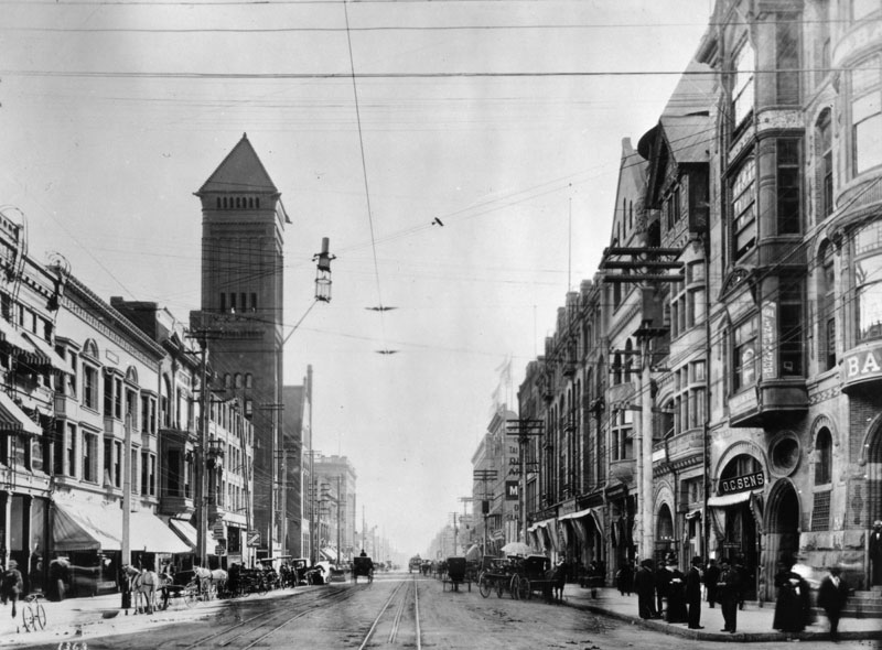
| (1888)^ - View looking south on Broadway from 2nd Street showing the new City Hall. It was built in 1888 to replace the City Hall seen in previous two photos. |
Historical Notes The new City Hall with its rectangular tower was located at 226 So. Broadway. Built in 1888, it was used until 1928 when the current City Hall was completed. Click HERE to see more early views of the 1888-built City Hall. |
* * * * * |
Main Street
 |
|
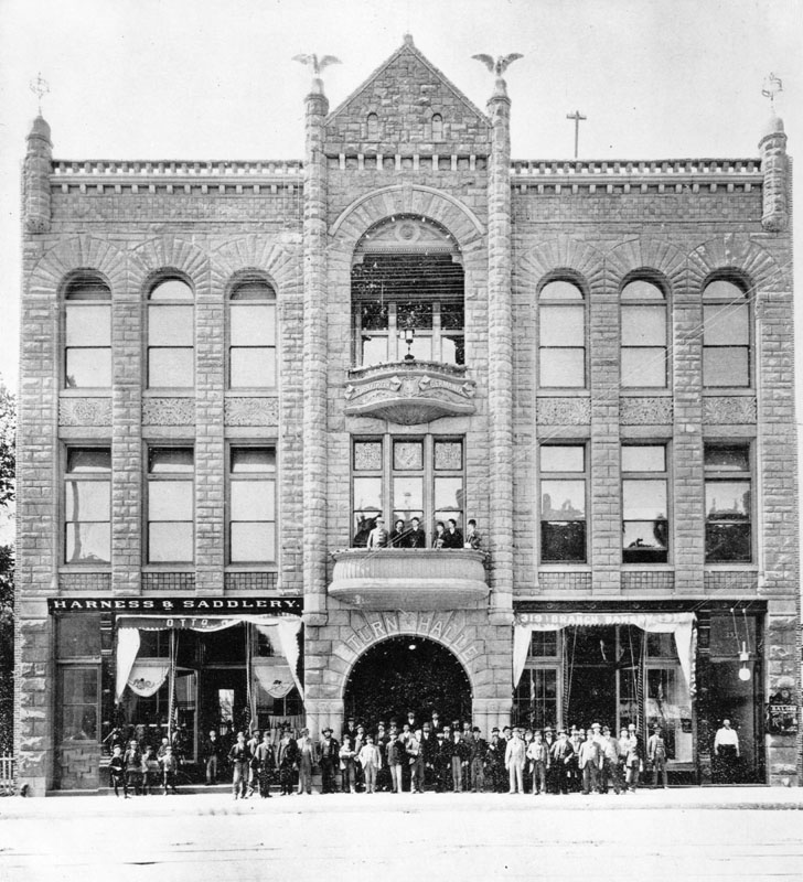
| (1888)* - Exterior view of the new Turnverein building located at 321 So. Main Street. It has a group posing in front. This was a club of German Americans. |
 |
|
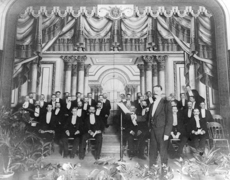
| (1888)^ - Photo of the first concert given by the Ellis Club, the first male chorus in Southern California, started by C. J. Ellis and three friends and organized on April 6, 1888. There were 16 men. The concert was given on July 19, 1888, at Turnverein Hall, with 40 singers. Conductor was Harold Burton. Charles James Ellis, founder, is in the last row, first person left of the center aisle. |
* * * * * |
Spring Street
 |
|
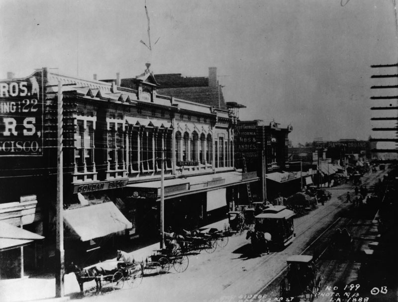
| (1888)^ - View looking south on Spring between 1st and 2nd streets. Horse-drawn buggies are parked in front a commercial building on the left. The sign above the large awning reads: GORDON BROS. A horse-drawn streetcar is seen heading north on Spring Street. Click HERE to see more on horse-drawn streetcars. |
.jpg) |
|
| (ca. 1888)* – View of Spring Street looking north from near 4th Street. In the far distance can be seen the Bryson-Bonebrake Block at the northwest corner of Spring and 2nd streets. |
* * * * * |
Bryson-Bonebrake Block (Spring and 2nd)
 |
|
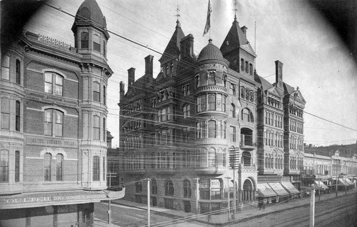
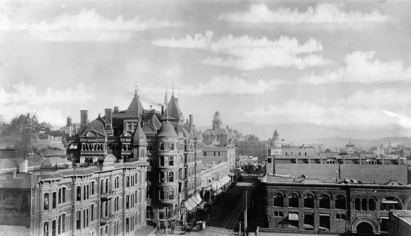
| (ca. 1888)^ - View looking at the northwest corner of 2nd and Spring streets showing the newly built Bryson-Bonebrake Block. On the left is the Hollenbeck Block shortly after it was enlarged to include a 3rd and 4th floor. Just to the left of the Bryson-Bonebrake Block can be seen part the short-lived City Hall Building (1884 - 1888). |
Historical Notes The Bryson-Bonebrake Block was one of the more important office buildings built during the 1880s building boom in Los Angeles. It had six stories, with a typical Queen Anne Style variety of shapes, materials and ornamentation for which architect John Cather Newsom was famous. |
 |
|
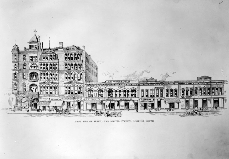
| (ca. 1888)^ - Drawing of the west side of Spring Street, including the Bryson-Bonebrake Block on the left, between 1st and 2nd Streets as it appeared circa 1888. |
Historical Notes Designed by architects Joseph Carter Newsom and Samuel Newsom, the Bryson-Bonebrake Block was completed in 1888. The 126-room bank and office building cost $224,000, a staggering sum at the time. Bonebrake was one of the richest men in the city at the time, and he could afford making such an investment. He located the main headquarters of his bank in the Bryson-Bonebrake Block. |
 |
|
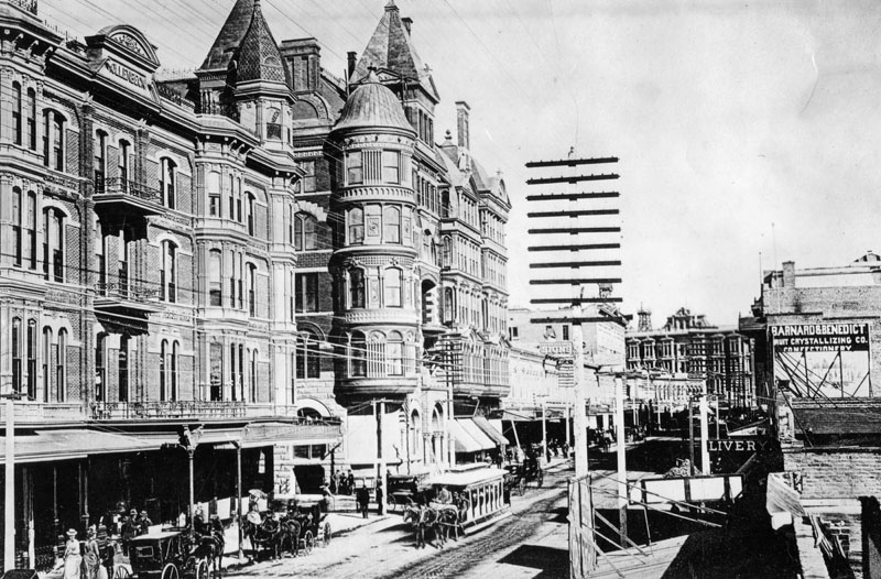
| (ca. 1888)^ - Spring Street looking north from the roof of the Stowell Building at 2nd Street. The Hollenbeck Block/Hotel is the first building on the left, next the Bryson-Bonebrake Block (n/w corner of 2nd and Spring). Also seen in the background are the LA County Courthouse, roof of Phillips Block, Temple Market Block and Baker Block. |
 |
|
| (1888)^ - View of Spring Street at 2nd Street, looking north. The Hollenbeck Hotel is on the left (southwest corner). The Bryson-Bonebrake Block can be seen across the street on the northwest corner. A horse-drawn streetcar is in the middle of the street and two horse-drawn carriages are seen parked at the curb. |
Historical Notes Horse-drawn streetcars remained the primary mode of public transportation through the 1880s, at their peak rolling through much of the booming city of Los Angeles. But soon technological innovation would doom the horse-powered street railway with the introduction of electric cable streetcars. |
* * * * * |
Los Angeles Cable Railway Viaduct
 |
|
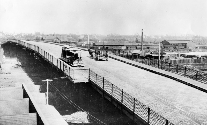
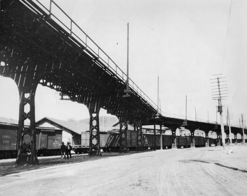
| (ca. 1889)^ - View over the 1st Street viaduct with a L.A. Cable Railway car and a horse-drawn wagon crossing the viaduct. The Los Angeles Terminal railway depot, yards, and roundhouse are shown. In foreground below, at track level, is an Atlantic and Pacific flatcar. |
Historical Notes Incorporated in 1887, the Los Angeles Cable Railway became the largest transit system in the city at the time, operating approximately 21 miles of track. Its lines ran from Boyle Heights and East Los Angeles westward to Westlake Park and Grand Avenue. In service from 1889 to the early 1900s, the system moved cars by means of a continuously running underground cable, powered by large steam engines housed at a central powerhouse at 2nd and Boylston Streets. Each car had a gripman who engaged or released a mechanical grip to control movement along the cable, which ran at a constant speed. The cable system was later renamed the Pacific Railway Company in 1889 and was the last city line to convert to electric streetcars. It was ultimately acquired by Henry E. Huntington in 1902, becoming part of his expanding electric rail empire. |
 |
|
| (ca. 1889)* - View of the Los Angeles Cable Railroad viaduct at Spring Street which crossed the LA River to Downey Ave. |
Historical Notes In 1888 a cable line succeeded the old horse car line which went over the old North Spring Street bridge to Downey Avenue, East Los Angeles. The cables were carried over the Southern Pacific freight yards to the bridge on this old viaduct. Its use was abandoned in 1904 and it was torn down in 1910. Counting this old viaduct as a part of the old North Spring Street bridge, that ancient wooden structure was more than two miles long. Downey Avenue is now the portion of North Broadway east of the Los Angeles River. |
 |
|
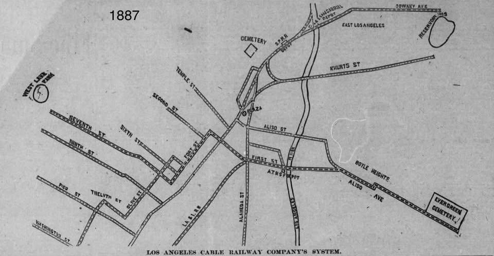
| (1887)* - Map showing Los Angeles Cable Railway Company’s system. Map courtesy of David Kimbrough. |
Historical Notes Los Angeles Cable Railway became the largest transit system in the city at the time, operating approximately 21 miles of track. Its lines ran from Boyle Heights and East Los Angeles westward to Westlake Park and Grand Avenue. |
 |
|
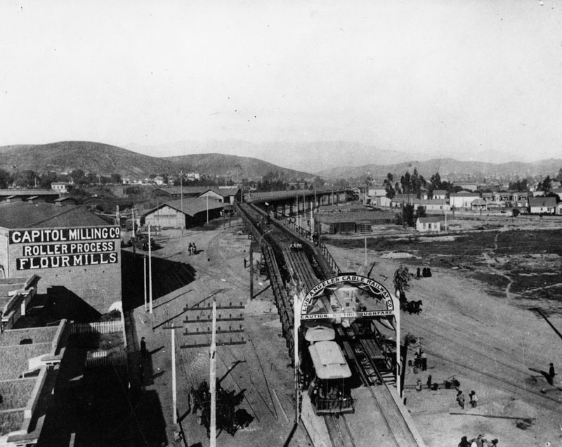
| (ca. 1889)* - Los Angeles Cable Railroad viaduct at Spring Street and College Street. The Capitol Milling Company and the old Central Pacific (later Southern Pacific) freight house can be seen in the distance. At that time this was the center of commerce activity for the city. |
Historical Notes Amazingly, the building with the company name still stands. The new Los Angeles to Pasadena light rail line (The Gold Line) passes directly in front of the building on an elevated structure, with the Chinatown station located just to the left of the cable cars in the photo above. |
 |
|
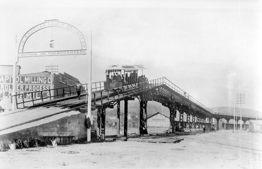
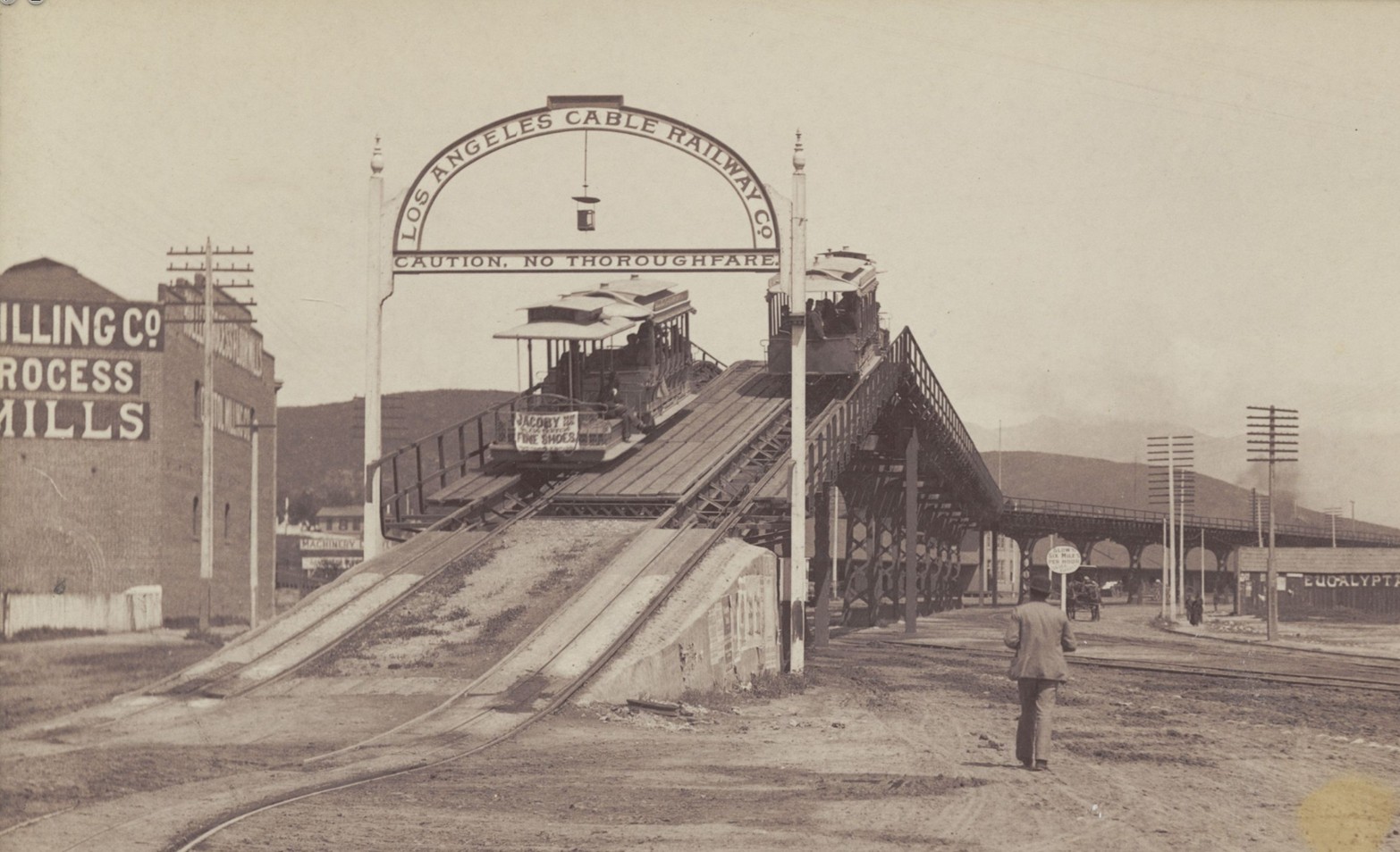
| (ca. 1889)* - Streetcar coming over the south end of the Los Angeles Cable Railroad viaduct at Spring Street and College Street. The elevated viaduct comes in from the distance at right, extending into the left foreground where a streetcar and its trailer car make their way down the off-ramp full of passengers, a pedestrian in front of them. The sign over the exit-way reads "Caution, no Thoroughfare." The Capitol Milling Company building is partially visible in the background. Utility poles stand, off in the distance to the right, along with hills. The caption under the photo reads "Though Horses and Buggies Created the Traffic Problems About 1889, the Los Angeles Cable Railway Used This Elevated Viaduct". |
Historical Notes At the time, this was one of the most extensive cable-worked railroads in operation in the U.S., its length being about twenty-one miles of single track, worked by three power stations. Click HERE to see more in an 1891 Scientific American Article on the LA Cable RR Viaduct. |
 |
|
| (ca. 1891)* – The Los Angeles Cable Railway’s elevated viaduct near Spring and College Streets, showing cable cars ascending and descending the steep wooden ramp over the Southern Pacific rail yards. The Capitol Milling Company building stands at left. This structure was sometimes referred to in early sources as the “San Fernando Street Viaduct,” reflecting the former name of this section of Spring Street. |
Historical Notes This dramatic wooden viaduct was part of the Los Angeles Cable Railway system, built in the late 1880s to carry cable cars from downtown Los Angeles across the Southern Pacific freight yards and toward East Los Angeles. The steep incline led to and from College Street and passed near the Capitol Milling Company, which still stands today. Though often labeled the Spring Street Viaduct—especially in modern references—some contemporary and archival sources refer to it as the San Fernando Street Viaduct. That’s because the portion of North Spring Street north of Temple was originally known as San Fernando Street in the 19th century. The name “Spring Street” became standard in the 1890s, but the older name persisted in some documents. The viaduct was dismantled in the early 20th century after electric streetcars replaced the cable system. The Capitol Milling Company building, seen at left in the photo, still stands today at 1231 N. Spring Street near College Street in Chinatown. Founded in the 1850s, it was one of Los Angeles' oldest family-run businesses and operated as a working mill until 1998. The building has since been preserved and adaptively reused. The Metro A Line (formerly Gold Line) now passes directly in front of it on an elevated track, with the Chinatown Station located just a block away. |
 |
|
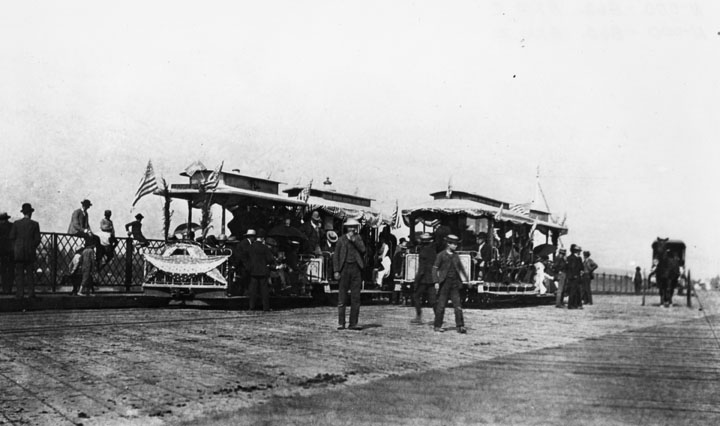
| (1889)^ - View of opening day for the Los Angeles Cable Railway to Boyle Heights at the First Street Bridge on August 1, 1889 |
* * * * * |
Los Angeles Cable Railway - Boyle Heights
 |
|
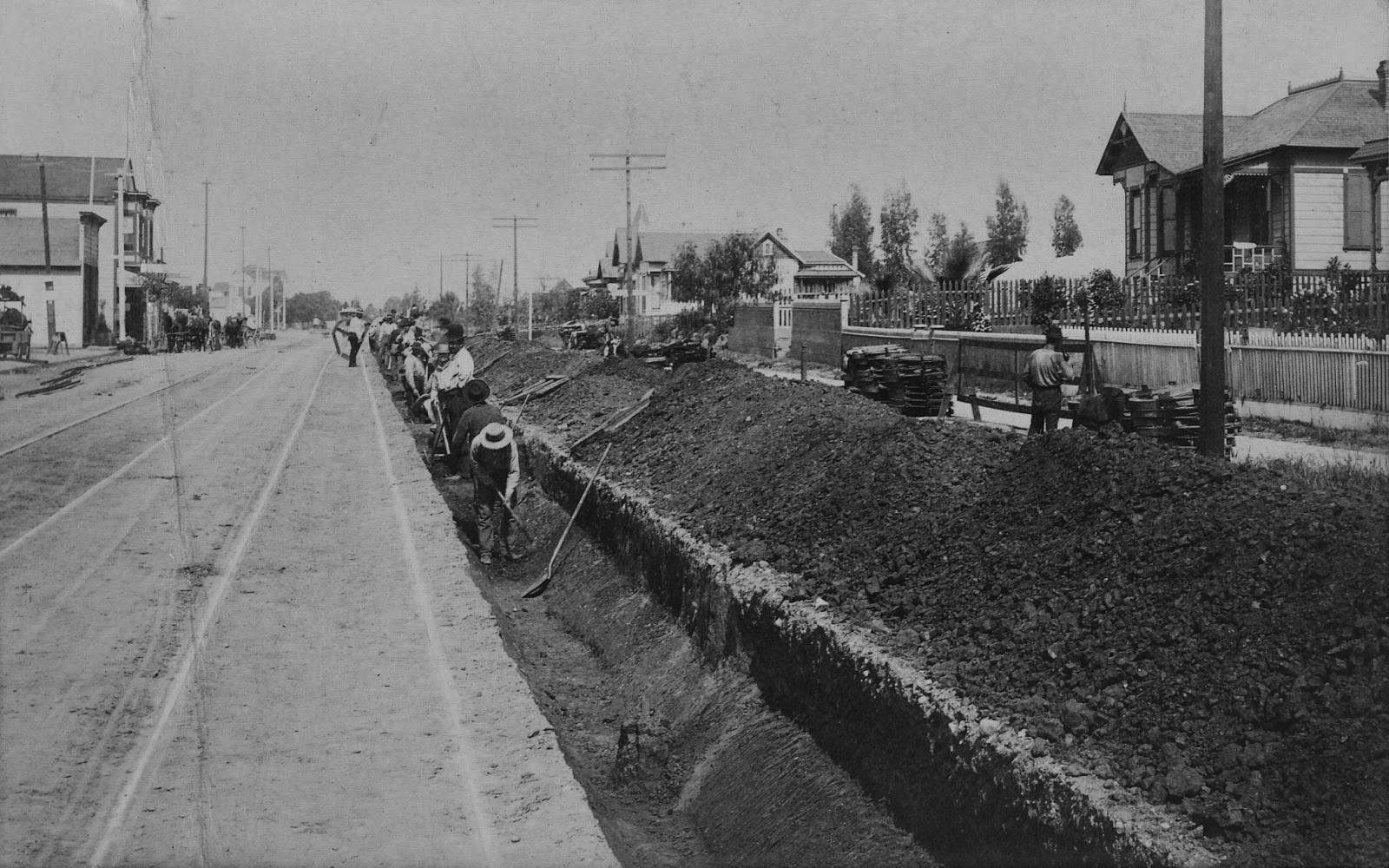
| (1889)* - A crew of workers is busily employed digging a trench to prepare for the tracking for the Los Angeles Cable Railway at First near State streets. At the right are a couple of residences, while some commercial buildings are down the street and to the left. |
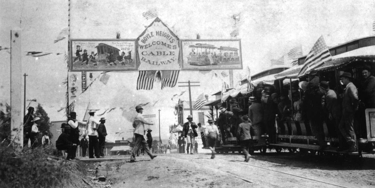
Historical Notes Los Angeles Cable Railway was the largest transit venture in the city, operating from Boyle Heights and East Los Angeles out to Westlake Park and Grand Avenue. The opening of the viaduct line over the LA River benefited real estate developers and residents in the Boyle Heights area. |
 |
|
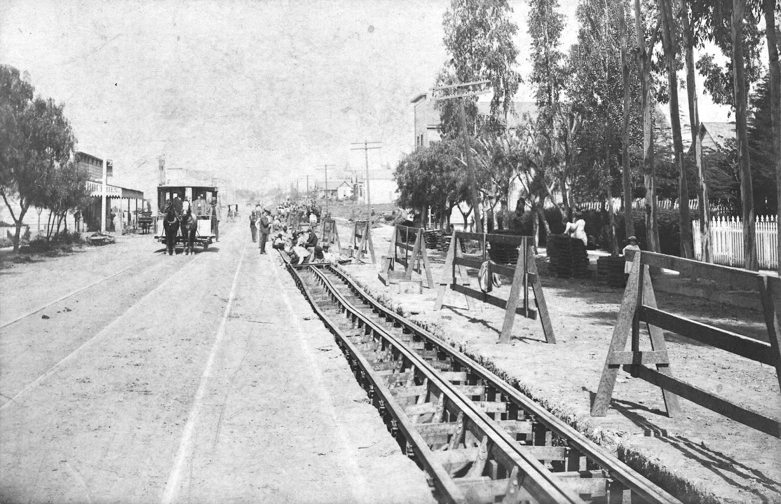
| (1889)* – View showing the laying of the Los Angeles Cable Railway's tracking system along First Street near Cummings in Boyle Heights. Notice that a horse-drawn streetcar has been halted to demonstrate the contrast of the "old-fashioned" 1870s system to the new technology of the cable system. A mixture of residential and commercial buildings, including a grocery near the streetcar at the left, are partially in view. |
Historical Notes Notation on the reverse side of photos reads: "Broad gauge, double track horse car line, which W.H. Workman built to Boyle Hts & sold to cable company." |
 |
|
| (1889)^*# - View of the inauguration of cable railway in Boyle Heights which became Los Angeles' first streetcar suburb. |
 |
|
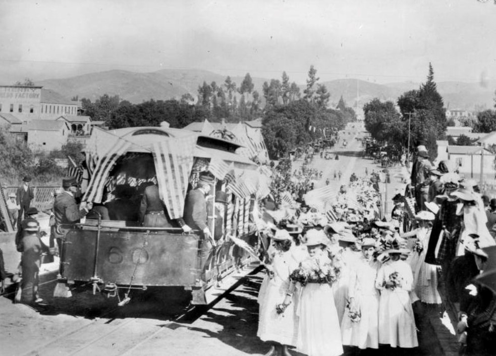
| (1889)^^ - Residents celebrate the 1889 opening of the Los Angeles Cable Railway's in East Los Angeles. |
Historical Notes The owners of the Los Angeles Cable Railway Company ran into financial difficulty and had to sell their controlling interest to C. B. Holmes, and associates, of Chicago, Ill. They organized a new company, known as the Pacific Railway Company, capitalized at $5,000,000.00 and finished the construction of the cable lines, which when completed covered many of the LA streets with double tracks. |
* * * * * |
More Historical Early Views
Newest Additions
Early LA Buildings and City Views
History of Water and Electricity in Los Angeles
* * * * * |
References and Credits
* DWP - LA Public Library Image Archive
^ LA Public Library Image Archive
*#Publications of the Historical Society of Southern California, Volume 9: Eternity Street
*#^Historic Hotels of Los Angeles and Hollywood (USC - California Historic Society):; Belmont Hotel
***Los Angeles Historic - Cultural Monuments Listing
*v*OnBunkerHill.org: Second Street Cable Railway
*^*California Historical Landmarks Listing (Los Angeles)
*^#Public Art in LA: Campo Santo
^^^LA Times: The Gush of Oil Was Music to 'Queen's' Ears
^*#Noirish Los Angeles - forum.skyscraperpage.com; Sunset and San Fernando Hotels; Belmont Hotel View; 1st Electric Trolley
*##Metro.net - Los Angeles Transit History
^##California State Library Image Archive
###Denver Public Library Image Archive
#^*Flickr.com: Michael Ryerson
#**Historic Los Angeles Theaters: Child's Opera House
#*^LA Conservancy: Boyle Hotel
#^^Historical Buildings - boyleheightsbeat.com
+^^Kansas Historic Society: Atchison, Topeka, and Santa Fe Railway Company
+++Mt. Lowe Preservation Society
*#*KCET - Inventing LA: Port of Los Angeles; Belmont Hotel View; A Brief History of Palm Trees; How LA Lost One of its Earliest Parks; Rediscovering Downtown L.A.'s Lost Neighborhood of Bunker Hill; Fort St. to Broadway
**#The Cable-Car-Guy.com: The Los Angeles Railway; Temple Street Cable Railway
**^History Matters: Calle de los Negros, 1880s
^^*LA Fire Department Historical Archive; Belmont Hotel Fire
****Theeastsiderla.com: Angelino Heights Oil Boom
^^#^The George A. Eslinger Street Lighting Photo Gallery
*##^The Street Railway History of Los Angeles - erha.org
^##*Pacific Coast Architecture Database (PCAD): Bryson-Bonebrake Block
^#^*Nathan Masters: Los Angeles From the Air, 1887 vs. 2013
^^^*Rails West: City Street Railways
^*^* KCET: LA's First Streetcars
^*^^San Fernando Valley Historical Society/Facebook.com: Burbank Villa Hotel
^*#*Panoramonview.org: Paorama of the Siege of Paris
^^^#LA Creek Freak: Arroyo de los Reyes
*^^*Los Angeles Past: Requena/Market St.
*^^#Boyle Heights History Blog: Los Angeles Cable Railway Construction
*^*#Paradise Leased: Arcadia Hotel
^^**LMU Digital Collection: Arcadia Hotel
*#*#Santa Monica Beach Stories
^#^# San Fernando Valley Relics: The Palms of San Fernando
#*^*The River Project: Taylor Yard
#^**Facebook.com: West San Fernando Valley Then And Now
#^*^Calisphere: University of California Image Archive
#^^^Southland.gizmodo.com: LA Once Had Cable Cars
##^^Flickr.com: Views of Los Angeles
^**^Wikipedia Images: Early L.A. Oil Wells

*^ Wikipedia: Arcadia Bandini de Stearns Baker; Bunker Hill; Prudent Beaudry; Jonathan Temple; Los Angeles High School; Joseph Widney; Pershing Square; Port of Los Angeles; Belmont High School; Hollenbeck Park; Ducommun; Isaias W. Hellman; Abel Stearns; Sawtelle, Los Angeles; Sawtelle Veterans Home; Arcade Station; Alhambra; Fort Moore; History of Santa Monica; History of Los Angeles; Burbank; Belmont High School; Mt. Lowe Railway; Los Angeles City Oil Field; History of Los Angeles Population Growth; Garvanza, Los Angeles; Highland Park; Compton; Harrison Gray Otis; Los Angeles City Hall; Angelino Heights; Boyle Heights; Boyle Hotel - Cummings Block; History of Transportation in California; Mount Lowe Railway
< Back